Jigsaw Puzzle > North America > United States of America > New York > New York > Maps
Jigsaw Puzzle : NYC Region and Long Island Map


![]()
Jigsaw Puzzles from Fine Art Storehouse
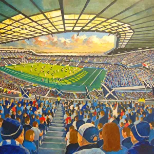
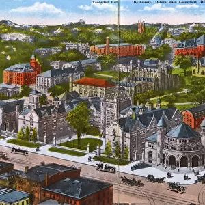
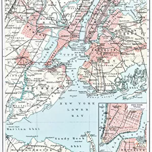
NYC Region and Long Island Map
A map of the region around New York City and Long Island, including New Jersey and the coast of Connecticut. Includes major highways, cities, and lakes
Unleash your creativity and transform your space into a visual masterpiece!
Media ID 21006797
Long Island New York City New York State Road Map Vector Major Road New York Harbour
Jigsaw Puzzle (1014 Pieces)
Discover the intricacies of the bustling NYC region and Long Island with our captivating jigsaw puzzle from Media Storehouse's Fine Art Storehouse collection. This puzzle showcases an exquisite map, meticulously detailed and revealing major highways, cities, and lakes. Journey through the vibrant landscape of New York City, New Jersey, and the coast of Connecticut. Challenge yourself and your family with this engaging puzzle, perfect for all ages and skill levels. Transport yourself to the heart of the East Coast and create a beautiful piece of art that you can treasure for years to come.
Made in the USA, 1014-piece puzzles measure 20" x 30" (50.8 x 76.2 cm). Every puzzle is meticulously printed on glossy photo paper, which has a strong 1.33 mm thickness. Delivered in a black storage cardboard box, these puzzles are both stylish and practical. (Note: puzzles contain small parts and are not suitable for children under 3 years of age.)
Jigsaw Puzzles are an ideal gift for any occasion
Estimated Product Size is 76cm x 50.8cm (29.9" x 20")
These are individually made so all sizes are approximate
Artwork printed orientated as per the preview above, with landscape (horizontal) orientation to match the source image.
FEATURES IN THESE COLLECTIONS
> Fine Art Storehouse
> Map
> Historical Maps
> Maps and Charts
> Related Images
> North America
> United States of America
> Connecticut
> Related Images
> North America
> United States of America
> Lakes
> Related Images
> North America
> United States of America
> Maps
> North America
> United States of America
> New Jersey
> Jersey City
> North America
> United States of America
> New Jersey
> Related Images
> North America
> United States of America
> New York
> New York
> Maps
> North America
> United States of America
> New York
> Related Images
EDITORS COMMENTS
This print showcases the intricate and expansive web of roads, cities, and natural features that make up the vibrant NYC Region and Long Island. With meticulous detail, this map encompasses not only New York City itself but also stretches across neighboring states such as New Jersey and Connecticut. The viewer is immediately drawn to the prominent highways that crisscross the region like lifelines connecting bustling urban centers. These major arteries serve as vital conduits for transportation, facilitating movement between cities while symbolizing the constant flow of life in this dynamic area. From a bird's-eye perspective, one can appreciate how this map encapsulates both man-made marvels and natural wonders. The sprawling metropolis of New York City stands out with its iconic skyline dominating the landscape, juxtaposed against serene lakes dotting the countryside. While devoid of human presence, this illustration exudes an energy that captures the essence of a thriving region constantly on-the-go. It serves as a reminder of how interconnected our world has become through modern infrastructure and transportation systems. Whether you are an avid traveler or simply fascinated by geography, this vector-based artwork offers an opportunity to explore every nook and cranny of this diverse region from afar. A perfect addition to any collection or space seeking to evoke a sense of wonderment about one of America's most influential hubs - without mentioning commercial use!
MADE IN THE USA
Safe Shipping with 30 Day Money Back Guarantee
FREE PERSONALISATION*
We are proud to offer a range of customisation features including Personalised Captions, Color Filters and Picture Zoom Tools
SECURE PAYMENTS
We happily accept a wide range of payment options so you can pay for the things you need in the way that is most convenient for you
* Options may vary by product and licensing agreement. Zoomed Pictures can be adjusted in the Cart.