Jigsaw Puzzle > Europe > United Kingdom > England > Southampton
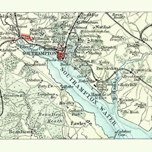
Jigsaw Puzzle : Southampton England map 1895


![]()
Jigsaw Puzzles from Fine Art Storehouse
Southampton England map 1895
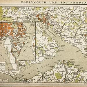
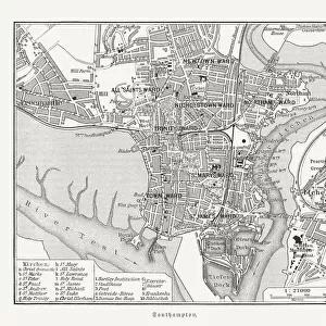
Meyers Konversations-Lexikon. Ein Nachschlagewerk des allgemeinen Wissens, 5th edition 17 volumes Bibliographisches Institut - Leipzig 1895-1897
Unleash your creativity and transform your space into a visual masterpiece!
THEPALMER
Media ID 13609309
© This content is subject to copyright
Harbor Port Southampton England
Jigsaw Puzzle (520 Pieces)
Discover the rich history of Southampton, England with our exquisite jigsaw puzzle from Media Storehouse. This captivating puzzle features an intricately detailed map of Southampton from the 5th edition of Meyers Konversations-Lexikon, published in 1895 by Bibliographisches Institut. The vintage map, sourced from THEPALMER at Fine Art Storehouse, takes you back in time, inviting you to explore the intricacies of this historic port city. Assemble the puzzle pieces to reveal the fascinating details of Southampton's urban layout and architectural landmarks from over a century ago. A perfect addition to any home or office, this jigsaw puzzle is not just a pastime, but a journey through time.
Made in the USA, 520-piece puzzles measure 16" x 20" (40.6 x 50.8 cm). Every puzzle is meticulously printed on glossy photo paper, which has a strong 1.33 mm thickness. Delivered in a black storage cardboard box, these puzzles are both stylish and practical. (Note: puzzles contain small parts and are not suitable for children under 3 years of age.)
Jigsaw Puzzles are an ideal gift for any occasion
Estimated Product Size is 50.8cm x 40.5cm (20" x 15.9")
These are individually made so all sizes are approximate
Artwork printed orientated as per the preview above, with landscape (horizontal) or portrait (vertical) orientation to match the source image.
FEATURES IN THESE COLLECTIONS
> Fine Art Storehouse
> Map
> Historical Maps
> Europe
> United Kingdom
> England
> Maps
> Europe
> United Kingdom
> England
> Posters
> Europe
> United Kingdom
> England
> Southampton
> Maps and Charts
> Related Images
EDITORS COMMENTS
This print showcases a historical map of Southampton, England from the year 1895. The map is sourced from Meyers Konversations-Lexikon, an esteemed encyclopedia published in Leipzig between 1895 and 1897. With its detailed engravings and etchings, this antique illustration provides a fascinating glimpse into the city's past. The map highlights various aspects of Southampton, including its port and harbor, which have played significant roles in shaping the city's identity throughout history. Its horizontal layout allows for easy navigation through the streets and landmarks that were present during that era. As one explores this physical geography depiction, they can immerse themselves in the rich cartography that captures both the beauty and intricacies of Southampton at that time. From bustling city streets to serene coastal areas, this old map offers a comprehensive view of what life was like over a century ago. "ThePalmer" who curated this stunning print available at Fine Art Storehouse, has preserved not only a piece of history but also an artistic representation worth cherishing. Whether you are an enthusiast of vintage maps or simply intrigued by Southampton's heritage, this exquisite print will undoubtedly transport you back in time to experience the charm and allure of this English city as it once was.
MADE IN THE USA
Safe Shipping with 30 Day Money Back Guarantee
FREE PERSONALISATION*
We are proud to offer a range of customisation features including Personalised Captions, Color Filters and Picture Zoom Tools
SECURE PAYMENTS
We happily accept a wide range of payment options so you can pay for the things you need in the way that is most convenient for you
* Options may vary by product and licensing agreement. Zoomed Pictures can be adjusted in the Cart.