Jigsaw Puzzle > Europe > France > Canton > Landes
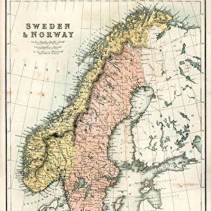
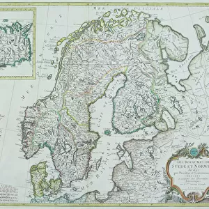
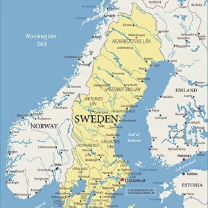
Jigsaw Puzzle : Sweden and Norway, lithograph, published in 1878


![]()
Jigsaw Puzzles from Fine Art Storehouse
Sweden and Norway, lithograph, published in 1878
Ancient map of Sweden and Norway. Lithograph, published in 1878
Unleash your creativity and transform your space into a visual masterpiece!
Media ID 13666801
© ZU_09
Atlantic Ocean Baltic Sea Contour Drawing Country Geographic Area Finland Land North Sea Norway Norwegian Culture Scandinavia Sweden Swedish Culture Topographic Map Topography Finnish Culture Obsolete
Jigsaw Puzzle (520 Pieces)
Step back in time with our exquisite Jigsaw Puzzle from Media Storehouse, featuring an ancient lithograph of Sweden and Norway, published in 1878 from the Fine Art Storehouse collection. Immerse yourself in the historical charm of this intricately detailed puzzle, as you piece together the rich tapestry of these two magnificent Nordic countries. Perfect for puzzle enthusiasts and history buffs alike, this puzzle offers a unique and engaging way to explore the past while enjoying the therapeutic benefits of puzzling. Let the adventure begin!
Made in the USA, 520-piece puzzles measure 16" x 20" (40.6 x 50.8 cm). Every puzzle is meticulously printed on glossy photo paper, which has a strong 1.33 mm thickness. Delivered in a black storage cardboard box, these puzzles are both stylish and practical. (Note: puzzles contain small parts and are not suitable for children under 3 years of age.)
Jigsaw Puzzles are an ideal gift for any occasion
Estimated Product Size is 40.5cm x 50.8cm (15.9" x 20")
These are individually made so all sizes are approximate
Artwork printed orientated as per the preview above, with landscape (horizontal) or portrait (vertical) orientation to match the source image.
FEATURES IN THESE COLLECTIONS
> Fine Art Storehouse
> Map
> Historical Maps
> Arts
> Artists
> O
> Oceanic Oceanic
> Europe
> Finland
> Related Images
> Europe
> France
> Canton
> Landes
> Europe
> Norway
> Related Images
EDITORS COMMENTS
This lithograph, published in 1878, takes us on a nostalgic journey through the rich history and cultural heritage of Sweden and Norway. The ancient map showcases the intricate topography of these Scandinavian lands, offering a glimpse into their past. Engraved with meticulous detail, this antique print reveals the contours of the land, from the majestic Baltic Sea to the vast North Sea and Atlantic Ocean. It beautifully captures not only geographical features but also highlights Swedish and Norwegian culture as well as Finnish influences within this region. As we immerse ourselves in this horizontal composition, our eyes wander across borders that have evolved over time. We are reminded of how these countries were once intertwined under shared histories while embracing their unique identities. The vertical contour drawing adds depth to our exploration, allowing us to visualize the diverse landscapes that define Sweden and Norway. With no people present in this image, it invites us to reflect upon how nature has shaped these nations throughout centuries. In an era where technology dominates cartography, this lithograph serves as a reminder of its obsolete charm. Its engraved beauty transports us back to 1878 when such maps were treasured possessions for those seeking knowledge about distant lands. Whether you appreciate art or harbor an interest in Scandinavian history, this lithographic print is sure to captivate your imagination with its timeless allure.
MADE IN THE USA
Safe Shipping with 30 Day Money Back Guarantee
FREE PERSONALISATION*
We are proud to offer a range of customisation features including Personalised Captions, Color Filters and Picture Zoom Tools
SECURE PAYMENTS
We happily accept a wide range of payment options so you can pay for the things you need in the way that is most convenient for you
* Options may vary by product and licensing agreement. Zoomed Pictures can be adjusted in the Cart.