Jigsaw Puzzle > Europe > Italy > Lazio > Rome
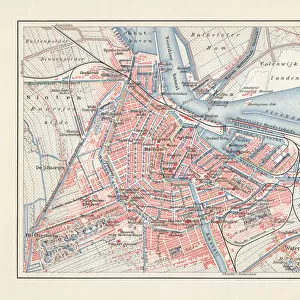
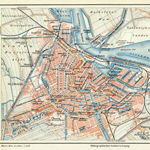
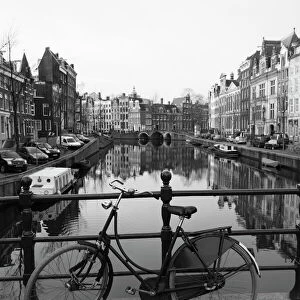
Jigsaw Puzzle : Map of city Amsterdam Netherlands from 1881


![]()
Jigsaw Puzzles from Fine Art Storehouse
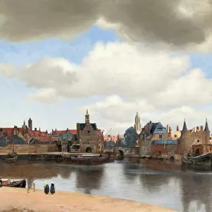
Map of city Amsterdam Netherlands from 1881
Map of city Amsterdam Netherlands from 1881
Original edition from my own archives
Source : Illustriertes Konversations Lexikon 1881
Unleash your creativity and transform your space into a visual masterpiece!
Grafissimo
Media ID 15372265
© This content is subject to copyright
Amsterdam City Street Continent Direction Hemisphere Macro Navigation Netherlands Road Map Rome Topography World Map
Jigsaw Puzzle (520 Pieces)
Discover the rich history of Amsterdam with our exquisite jigsaw puzzle from Media Storehouse, featuring the captivating "Map of City Amsterdam Netherlands from 1881" by Grafissimo from the Fine Art Storehouse. This intricately detailed puzzle, derived from the original edition of Illustriertes Konversations Lexikon 1881, invites you on a journey back in time. With each piece placed, the vibrant and intricate depiction of 19th-century Amsterdam unfolds before your eyes. Perfect for puzzle enthusiasts, history buffs, or anyone seeking a challenging and rewarding experience, this puzzle promises an enchanting escape into the past.
Made in the USA, 520-piece puzzles measure 16" x 20" (40.6 x 50.8 cm). Every puzzle is meticulously printed on glossy photo paper, which has a strong 1.33 mm thickness. Delivered in a black storage cardboard box, these puzzles are both stylish and practical. (Note: puzzles contain small parts and are not suitable for children under 3 years of age.)
Jigsaw Puzzles are an ideal gift for any occasion
Estimated Product Size is 50.8cm x 40.5cm (20" x 15.9")
These are individually made so all sizes are approximate
Artwork printed orientated as per the preview above, with landscape (horizontal) or portrait (vertical) orientation to match the source image.
FEATURES IN THESE COLLECTIONS
> Fine Art Storehouse
> Map
> Historical Maps
> Fine Art Storehouse
> Map
> Italian Maps
> Europe
> Italy
> Lazio
> Rome
> Europe
> Netherlands
> Amsterdam
> Europe
> Netherlands
> Maps
> Europe
> Netherlands
> Posters
> Europe
> Netherlands
> Related Images
> Maps and Charts
> Italy
> Maps and Charts
> Netherlands
> Maps and Charts
> Related Images
> Maps and Charts
> World
EDITORS COMMENTS
This print showcases a remarkable piece of history - the Map of Amsterdam, Netherlands from 1881. With its original edition sourced from the Illustriertes Konversations Lexikon, this map is a true gem from Grafissimo's personal archives. The intricate details and craftsmanship displayed in this antique map take us back to a bygone era, allowing us to explore the city streets and roads as they were over a century ago. The cartography and topography depicted on this print provide an invaluable glimpse into Amsterdam's past, offering insights into its development and growth. As we gaze upon this horizontal masterpiece, our eyes are drawn to every minute detail - from the direction markers guiding travelers through the bustling city to macro views of each neighborhood. This map not only captures Amsterdam but also hints at connections with other parts of Europe, Italy's Rome included. With its rich historical significance and undeniable beauty, this print serves as both an educational tool for enthusiasts of cartography and a stunning decorative piece for any space. Whether you're fascinated by navigation or simply appreciate fine art that tells stories of times long gone, let this Map of Amsterdam transport you back in time while adding elegance to your surroundings.
MADE IN THE USA
Safe Shipping with 30 Day Money Back Guarantee
FREE PERSONALISATION*
We are proud to offer a range of customisation features including Personalised Captions, Color Filters and Picture Zoom Tools
SECURE PAYMENTS
We happily accept a wide range of payment options so you can pay for the things you need in the way that is most convenient for you
* Options may vary by product and licensing agreement. Zoomed Pictures can be adjusted in the Cart.