Jigsaw Puzzle > Maps and Charts > Americas
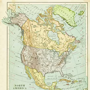
Jigsaw Puzzle : North America map 1898


![]()
Jigsaw Puzzles from Fine Art Storehouse
North America map 1898
Map from Physical Geography by R. S. Tarr - The MacMillan Company - London 1898
Unleash your creativity and transform your space into a visual masterpiece!
THEPALMER
Media ID 20773185
Jigsaw Puzzle (520 Pieces)
Discover the intrigue of the past with our Media Storehouse Jigsaw Puzzle featuring the historic North America map from 1898. This captivating puzzle, showcasing a vintage map by THEPALMER from the Fine Art Storehouse, is an excellent addition to any home or office. Based on the Physical Geography book by R.S. Tarr published by The MacMillan Company in London, this puzzle invites you to journey back in time and reconnect with history. With meticulously crafted pieces and vivid colors, this challenging yet rewarding puzzle promises an engaging experience for puzzle enthusiasts and history buffs alike. Immerse yourself in the rich details of this classic map and bring the past to life, piece by piece.
Made in the USA, 520-piece puzzles measure 16" x 20" (40.6 x 50.8 cm). Every puzzle is meticulously printed on glossy photo paper, which has a strong 1.33 mm thickness. Delivered in a black storage cardboard box, these puzzles are both stylish and practical. (Note: puzzles contain small parts and are not suitable for children under 3 years of age.)
Jigsaw Puzzles are an ideal gift for any occasion
Estimated Product Size is 40.5cm x 50.8cm (15.9" x 20")
These are individually made so all sizes are approximate
Artwork printed orientated as per the preview above, with landscape (horizontal) or portrait (vertical) orientation to match the source image.
FEATURES IN THESE COLLECTIONS
> Maps and Charts
> Related Images
EDITORS COMMENTS
This print showcases a remarkable piece of history, the North America map from 1898. Taken from the renowned book "Physical Geography" by R. S. Tarr and published by The MacMillan Company in London, this vintage map offers us a glimpse into the past when cartography was both an art and a science. The intricate details of this map are truly awe-inspiring. Every contour, river, mountain range, and coastline has been meticulously depicted with utmost precision. As we gaze upon it, we can't help but marvel at the immense effort that went into creating such a comprehensive representation of North America over a century ago. This particular print is brought to life through THEPALMER's expert craftsmanship and attention to detail. The colors have been beautifully preserved, allowing us to appreciate the original hues that adorned this historical document. It serves as a testament to our ever-evolving understanding of geography and how far we've come since then. Whether you're an avid collector or simply fascinated by history, this print is sure to captivate your imagination. Displaying it on your wall will not only add an air of sophistication but also serve as a constant reminder of our planet's rich heritage. Immerse yourself in nostalgia as you explore every inch of this exquisite North America map from 1898 – an extraordinary piece that transcends time itself.
MADE IN THE USA
Safe Shipping with 30 Day Money Back Guarantee
FREE PERSONALISATION*
We are proud to offer a range of customisation features including Personalised Captions, Color Filters and Picture Zoom Tools
SECURE PAYMENTS
We happily accept a wide range of payment options so you can pay for the things you need in the way that is most convenient for you
* Options may vary by product and licensing agreement. Zoomed Pictures can be adjusted in the Cart.