Jigsaw Puzzle > Arts > Landscape paintings > Waterfall and river artworks > River artworks
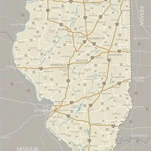
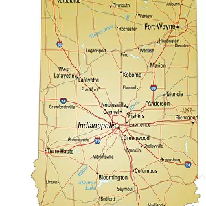
Jigsaw Puzzle : Map of Illinois showing major cities and roads


![]()
Jigsaw Puzzles from Fine Art Storehouse
Map of Illinois showing major cities and roads
Vector illustration of map of Illinois with major roads, rivers and lakes
Unleash your creativity and transform your space into a visual masterpiece!
Media ID 15054815
Jigsaw Puzzle (520 Pieces)
Discover the beauty and charm of the American Heartland with our intricately designed Jigsaw Puzzle from Media Storehouse's Fine Art Storehouse collection. This captivating puzzle features a detailed vector illustration of a map of Illinois, showcasing the major cities and roads that crisscross the state. Ideal for puzzle enthusiasts and history buffs alike, this educational and engaging puzzle is a perfect addition to your collection or a thoughtful gift for a loved one. Dive into the excitement of piecing together this stunning representation of the Land of Lincoln, and unlock a new appreciation for the Midwest's rich history and geography.
Made in the USA, 520-piece puzzles measure 16" x 20" (40.6 x 50.8 cm). Every puzzle is meticulously printed on glossy photo paper, which has a strong 1.33 mm thickness. Delivered in a black storage cardboard box, these puzzles are both stylish and practical. (Note: puzzles contain small parts and are not suitable for children under 3 years of age.)
Jigsaw Puzzles are an ideal gift for any occasion
Estimated Product Size is 40.5cm x 50.8cm (15.9" x 20")
These are individually made so all sizes are approximate
Artwork printed orientated as per the preview above, with landscape (horizontal) or portrait (vertical) orientation to match the source image.
FEATURES IN THESE COLLECTIONS
> Fine Art Storehouse
> Map
> Reference Maps
> Arts
> Landscape paintings
> Waterfall and river artworks
> River artworks
> Maps and Charts
> Related Images
EDITORS COMMENTS
This print showcases a meticulously detailed map of Illinois, revealing the state's major cities, roads, rivers, and lakes. Crafted with precision and presented as a vector illustration, this artwork from Fine Art Storehouse is an exquisite representation of cartographic artistry. The map effortlessly guides our gaze across the vast landscape of Illinois, highlighting its urban centers such as Chicago, Springfield, Peoria, and Rockford. Each city is marked by a distinct symbol that adds visual appeal to the composition. The intricate network of roads connects these bustling metropolises like veins running through the heartland. As we explore further into this stunning depiction of Illinois' topography, we encounter meandering rivers gracefully flowing across the land. From the mighty Mississippi River on its western border to the serene Fox River in the east – each waterway contributes to both beauty and functionality within this diverse state. Moreover, numerous lakes dotting this artistic rendition provide not only scenic tranquility but also recreational opportunities for residents and visitors alike. These shimmering bodies of water offer respite from daily life while enhancing Illinois' natural charm. Whether you are an avid traveler or simply appreciate fine art prints that celebrate geography's allure – this remarkable piece captures both accuracy and aesthetic appeal. It serves as a testament to human ingenuity in mapping out our surroundings while simultaneously reminding us of nature's inherent beauty found within every corner of Illinois' borders.
MADE IN THE USA
Safe Shipping with 30 Day Money Back Guarantee
FREE PERSONALISATION*
We are proud to offer a range of customisation features including Personalised Captions, Color Filters and Picture Zoom Tools
SECURE PAYMENTS
We happily accept a wide range of payment options so you can pay for the things you need in the way that is most convenient for you
* Options may vary by product and licensing agreement. Zoomed Pictures can be adjusted in the Cart.