Jigsaw Puzzle > Maps and Charts > World
Jigsaw Puzzle : World map, continent labels


![]()
Jigsaw Puzzles from Fine Art Storehouse
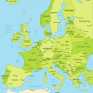
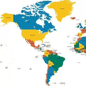
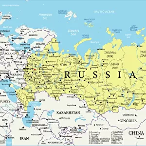
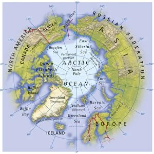
World map, continent labels
2011 edition
Unleash your creativity and transform your space into a visual masterpiece!
Media ID 14430994
Jigsaw Puzzle (1014 Pieces)
Discover the wonders of our planet with the Media Storehouse World Map Jigsaw Puzzle from Fine Art Storehouse (2011 edition)! This intricately detailed puzzle features a captivating image of a world map with clear continent labels, making it an ideal challenge for both beginners and seasoned puzzle enthusiasts. Assemble this global masterpiece to expand your geographical knowledge and ignite your sense of adventure. Immerse yourself in the joy of piecing together the beautiful lands, seas, and borders of our diverse world. Engaging and educational, this puzzle is a must-have for families, classrooms, and anyone with a passion for travel and exploration.
Made in the USA, 1014-piece puzzles measure 20" x 30" (50.8 x 76.2 cm). Every puzzle is meticulously printed on glossy photo paper, which has a strong 1.33 mm thickness. Delivered in a black storage cardboard box, these puzzles are both stylish and practical. (Note: puzzles contain small parts and are not suitable for children under 3 years of age.)
Jigsaw Puzzles are an ideal gift for any occasion
Estimated Product Size is 76cm x 50.8cm (29.9" x 20")
These are individually made so all sizes are approximate
Artwork printed orientated as per the preview above, with landscape (horizontal) orientation to match the source image.
FEATURES IN THESE COLLECTIONS
> Fine Art Storehouse
> Map
> Reference Maps
> Maps and Charts
> Related Images
> Maps and Charts
> World
EDITORS COMMENTS
This print titled "World map, continent labels (2011 edition)" from Fine Art Storehouse is a visual masterpiece that effortlessly combines artistry and education. The intricate details of this map take us on an enchanting journey across the globe, allowing us to explore the vastness and diversity of our planet. The vibrant colors used in this print bring life to each continent, making them easily distinguishable. From the lush greenery of South America to the icy landscapes of Antarctica, every corner of the world is beautifully represented. The carefully labeled continents provide a valuable educational tool for both young learners and seasoned travelers alike. As we gaze upon this stunning artwork, we are reminded of how interconnected our world truly is. It serves as a reminder that despite our differences in culture, language, and geography, we all share one common home - Earth. This print captures not only geographical accuracy but also evokes a sense of wonderment about our planet's rich history and diverse cultures. Whether displayed in a classroom or as an eye-catching centerpiece in your living space, it sparks curiosity and invites exploration. With its timeless appeal and meticulous attention to detail, this Fine Art Storehouse print serves as an exquisite addition to any collection. It reminds us that there is always more to discover beyond what meets the eye – encouraging us to embrace adventure while cherishing the beauty found within our global community.
MADE IN THE USA
Safe Shipping with 30 Day Money Back Guarantee
FREE PERSONALISATION*
We are proud to offer a range of customisation features including Personalised Captions, Color Filters and Picture Zoom Tools
SECURE PAYMENTS
We happily accept a wide range of payment options so you can pay for the things you need in the way that is most convenient for you
* Options may vary by product and licensing agreement. Zoomed Pictures can be adjusted in the Cart.