Jigsaw Puzzle > Arts > Street art graffiti > Digital art > Digital paintings
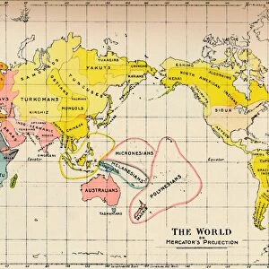
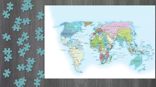
Jigsaw Puzzle : The world in 1900 showing how it was governed by different nations


![]()
Jigsaw Puzzles from Fine Art Storehouse
The world in 1900 showing how it was governed by different nations
Digital illustration of the world in 1900 showing how it was governed by different nations
Unleash your creativity and transform your space into a visual masterpiece!
Dorling Kindersley
Media ID 13541105
© This content is subject to copyright
1900 20th Century 20th Century Style Variation Western Script World Map Digitally Generated Digitally Generated Image
Jigsaw Puzzle (1014 Pieces)
Discover the fascinating political landscape of 1900 with our captivating jigsaw puzzle from Dorling Kindersley's Fine Art Storehouse. This intricately detailed puzzle, featuring "The World in 1900: A Political Map," invites you on a journey through time as you piece together the different nations and territories as they existed over a century ago. With vibrant colors and meticulous illustration, this puzzle is not only a fun and engaging activity for puzzle enthusiasts, but also an educational experience that will broaden your historical knowledge. Immerse yourself in the rich history of our world and bring the past to life with this captivating jigsaw puzzle from Media Storehouse.
Made in the USA, 1014-piece puzzles measure 20" x 30" (50.8 x 76.2 cm). Every puzzle is meticulously printed on glossy photo paper, which has a strong 1.33 mm thickness. Delivered in a black storage cardboard box, these puzzles are both stylish and practical. (Note: puzzles contain small parts and are not suitable for children under 3 years of age.)
Jigsaw Puzzles are an ideal gift for any occasion
Estimated Product Size is 76cm x 50.8cm (29.9" x 20")
These are individually made so all sizes are approximate
Artwork printed orientated as per the preview above, with landscape (horizontal) orientation to match the source image.
FEATURES IN THESE COLLECTIONS
> Fine Art Storehouse
> Photo Libraries
> Dorling Kindersley Prints
> Animals
> Mammals
> Muridae
> Western Mouse
> Arts
> Street art graffiti
> Digital art
> Digital paintings
> Maps and Charts
> Related Images
> Maps and Charts
> World
EDITORS COMMENTS
This digital illustration takes us back to the year 1900, providing a visual representation of how the world was governed by different nations during that time. The artist skillfully combines elements of cartography and cut-out techniques to create a stunning piece that showcases the geopolitical landscape of the past. The horizontal composition allows for easy exploration of this intricate artwork, which is devoid of any human presence. Against a clean white background, the world map takes center stage, with its vibrant colors and detailed borders indicating various territories controlled by different countries. In true 20th-century style, this digitally generated image captures the essence of an era when Western script dominated global governance. Each nation's name is meticulously labeled in clear typography, highlighting their distinct identities on this historical map. As we observe this studio shot print from Dorling Kindersley's collection at Fine Art Storehouse, it becomes evident that it serves as more than just decorative wall art. It invites viewers to reflect upon our shared history and ponder how political landscapes have evolved over time. This visually striking illustration sparks curiosity about international relations in 1900 while reminding us of our interconnectedness as citizens of today's diverse and ever-changing world.
MADE IN THE USA
Safe Shipping with 30 Day Money Back Guarantee
FREE PERSONALISATION*
We are proud to offer a range of customisation features including Personalised Captions, Color Filters and Picture Zoom Tools
SECURE PAYMENTS
We happily accept a wide range of payment options so you can pay for the things you need in the way that is most convenient for you
* Options may vary by product and licensing agreement. Zoomed Pictures can be adjusted in the Cart.