Jigsaw Puzzle > Animals > Mammals > Muridae > Western Mouse
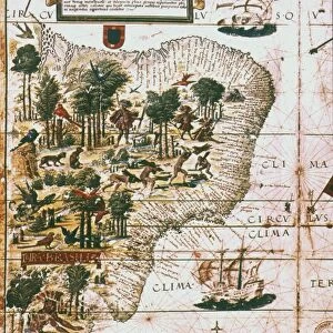
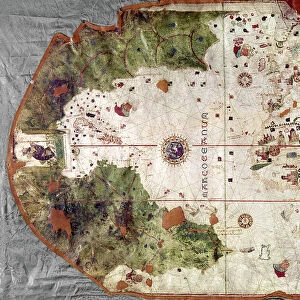
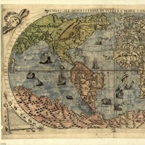
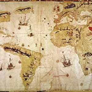
Jigsaw Puzzle : CANTINO WORLD MAP, 1502. Western half of the Cantino map of the world


![]()
Jigsaw Puzzles from Granger
CANTINO WORLD MAP, 1502. Western half of the Cantino map of the world
CANTINO WORLD MAP, 1502. Western half of the Cantino map of the world, 1502, showing (at left) the Tordesillas Treaty demarcation line of 1494 which divided the non-Christian (i.e. undiscovered) world between Spain and Portugal
Granger holds millions of images spanning more than 25,000 years of world history, from before the Stone Age to the dawn of the Space Age
Media ID 6622241
1502 Age Of Discovery New World Portolan Chart Portugal Portuguese Spain Spanish Topography World
Jigsaw Puzzle (520 Pieces)
Discover the fascinating world of yesteryears with our exquisite CANTINO WORLD MAP jigsaw puzzle from Media Storehouse. This captivating puzzle features the Western half of the Cantino map of the world, a rare and historically significant cartographic masterpiece from 1502. The intricate details of this puzzle showcase the Tordesillas Treaty demarcation line of 1494, marking the division between the Spanish and Portuguese spheres of influence. Immerse yourself in the mystery and history of this ancient map as you piece together the past, one puzzle piece at a time. Bring the rich tapestry of history into your home and create a memorable experience for the whole family.
Made in the USA, 520-piece puzzles measure 16" x 20" (40.6 x 50.8 cm). Every puzzle is meticulously printed on glossy photo paper, which has a strong 1.33 mm thickness. Delivered in a black storage cardboard box, these puzzles are both stylish and practical. (Note: puzzles contain small parts and are not suitable for children under 3 years of age.)
Jigsaw Puzzles are an ideal gift for any occasion
Estimated Product Size is 50.8cm x 40.5cm (20" x 15.9")
These are individually made so all sizes are approximate
Artwork printed orientated as per the preview above, with landscape (horizontal) or portrait (vertical) orientation to match the source image.
FEATURES IN THESE COLLECTIONS
> Granger Art on Demand
> Maps
> Animals
> Mammals
> Muridae
> Western Mouse
> Arts
> Art Movements
> Renaissance Art
> Europe
> Portugal
> Related Images
> Europe
> Spain
> Related Images
EDITORS COMMENTS
This print showcases the remarkable "CANTINO WORLD MAP, 1502" specifically focusing on its western half. Created during the Renaissance period, this masterpiece offers a glimpse into the Age of Discovery and the exploration of new lands by Portuguese and Spanish navigators. The highlight of this image is undoubtedly the Tordesillas Treaty demarcation line of 1494, prominently displayed at the left side. This historic agreement divided the yet-to-be-discovered non-Christian world between Spain and Portugal, marking their respective territories in uncharted waters. With intricate details and precision, this portolan chart provides an extraordinary topographical representation of both known and unknown regions. It serves as a testament to the incredible advancements made in cartography during that era. As we delve into this mesmerizing artwork, we are transported back in time to an age filled with curiosity and ambition. The Cantino map not only reflects Europe's thirst for exploration but also encapsulates their desire to expand their empires across distant horizons. This Granger Collection print allows us to appreciate not only its historical significance but also its artistic beauty. It serves as a reminder of humanity's relentless pursuit of knowledge and discovery throughout history.
MADE IN THE USA
Safe Shipping with 30 Day Money Back Guarantee
FREE PERSONALISATION*
We are proud to offer a range of customisation features including Personalised Captions, Color Filters and Picture Zoom Tools
SECURE PAYMENTS
We happily accept a wide range of payment options so you can pay for the things you need in the way that is most convenient for you
* Options may vary by product and licensing agreement. Zoomed Pictures can be adjusted in the Cart.