Jigsaw Puzzle > Europe > France > Paris > Maps
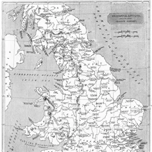
Jigsaw Puzzle : MAP OF ENGLAND, c1250. One of the earliest detailed maps of Great Britain extant


![]()
Jigsaw Puzzles from Granger
MAP OF ENGLAND, c1250. One of the earliest detailed maps of Great Britain extant
MAP OF ENGLAND, c1250.
One of the earliest detailed maps of Great Britain extant, drawn about 1250 A.D. by Matthew Paris, artist, historian and monk of St. Albans. Features emphasized are the two Roman walls, rivers, towns and the monastery of St. Albans ( cenobium Sancti Albani )
Granger holds millions of images spanning more than 25,000 years of world history, from before the Stone Age to the dawn of the Space Age
Media ID 12321022
1250 Alban Matthew Monastery Paris Saint
Jigsaw Puzzle (520 Pieces)
Discover the rich history of England with the Media Storehouse Jigsaw Puzzle featuring a rare and captivating map from the past. This intricately detailed puzzle, based on the "Map of England, c1250" by Matthew Paris, offers a unique glimpse into the early cartography of Great Britain. Drawn around 1250 A.D., this map is one of the earliest and most detailed records of the British Isles, making it an engaging and educational puzzle experience for history enthusiasts and jigsaw puzzle lovers alike. Immerse yourself in the past and connect the pieces to bring this piece of history back to life.
Made in the USA, 520-piece puzzles measure 16" x 20" (40.6 x 50.8 cm). Every puzzle is meticulously printed on glossy photo paper, which has a strong 1.33 mm thickness. Delivered in a black storage cardboard box, these puzzles are both stylish and practical. (Note: puzzles contain small parts and are not suitable for children under 3 years of age.)
Jigsaw Puzzles are an ideal gift for any occasion
Estimated Product Size is 40.5cm x 50.8cm (15.9" x 20")
These are individually made so all sizes are approximate
Artwork printed orientated as per the preview above, with landscape (horizontal) or portrait (vertical) orientation to match the source image.
FEATURES IN THESE COLLECTIONS
> Granger Art on Demand
> Maps
> Arts
> Art Movements
> Medieval Art
> Arts
> Artists
> R
> Roman Roman
> Arts
> Artists
> Related Images
> Arts
> Landscape paintings
> Waterfall and river artworks
> River artworks
> Arts
> Photorealistic artworks
> Detailed art pieces
> Masterful detailing in art
> Europe
> France
> Paris
> Maps
> Europe
> United Kingdom
> England
> Maps
> Europe
> United Kingdom
> England
> Rivers
> Europe
> United Kingdom
> England
> St Albans
> Maps and Charts
> Related Images
EDITORS COMMENTS
This print showcases a remarkable piece of history - the "Map of England, c1250". Crafted by Matthew Paris, an esteemed artist, historian, and monk from St. Albans, this map is regarded as one of the earliest detailed depictions of Great Britain that still exists today. Created around 1250 A. D. , it offers a fascinating glimpse into the medieval landscape. The map highlights several notable features with great precision. The two Roman walls are prominently displayed, serving as enduring reminders of Britain's ancient past. Rivers meander across the map, illustrating their significance in shaping the country's geography and providing vital transportation routes. Towns dotting the landscape indicate bustling centers of commerce and human activity during that era. Of particular interest is the inclusion of St. Albans Monastery (cenobium Sancti Albani). This renowned religious institution holds immense historical importance and was likely a source of pride for Matthew Paris himself as a monk from St. Albans. As we delve into this extraordinary artifact from centuries ago, we gain insight into both English history and cartography during medieval times. Its meticulous details offer us a window into how people perceived their world back then - an invaluable resource for scholars and enthusiasts alike.
MADE IN THE USA
Safe Shipping with 30 Day Money Back Guarantee
FREE PERSONALISATION*
We are proud to offer a range of customisation features including Personalised Captions, Color Filters and Picture Zoom Tools
SECURE PAYMENTS
We happily accept a wide range of payment options so you can pay for the things you need in the way that is most convenient for you
* Options may vary by product and licensing agreement. Zoomed Pictures can be adjusted in the Cart.