Jigsaw Puzzle > Granger Art on Demand > Plans and Diagrams
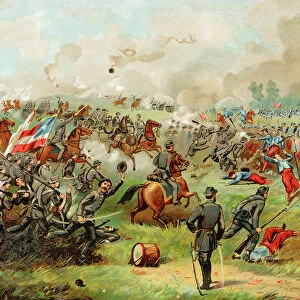
Jigsaw Puzzle : A map of the First Battle of Bull Run from a contemporary American newspaper


![]()
Jigsaw Puzzles from Granger
A map of the First Battle of Bull Run from a contemporary American newspaper
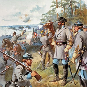
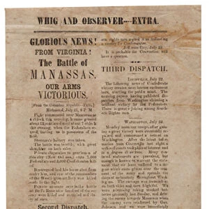
CIVIL WAR: BULL RUN, 1861.
A map of the First Battle of Bull Run from a contemporary American newspaper
Granger holds millions of images spanning more than 25,000 years of world history, from before the Stone Age to the dawn of the Space Age
Media ID 10410456
1861 Battle Bull Bull Run Confederate Army First Battle Of Bull Run Manassas Plan Southeastern Union Union Army United States Virginia Yankee
Jigsaw Puzzle (520 Pieces)
Discover history like never before with Media Storehouse's Jigsaw Puzzle collection. This intriguing puzzle presents a captivating map of the First Battle of Bull Run, as it was depicted in a contemporary American newspaper in 1861. Bring the excitement of the Civil War era into your home as you piece together this historically significant image from Granger Art on Demand. Engage in a fun and educational activity while immersing yourself in the rich details of this vintage newspaper map. Perfect for history enthusiasts, puzzle lovers, or anyone seeking a challenging and engaging pastime.
Made in the USA, 520-piece puzzles measure 16" x 20" (40.6 x 50.8 cm). Every puzzle is meticulously printed on glossy photo paper, which has a strong 1.33 mm thickness. Delivered in a black storage cardboard box, these puzzles are both stylish and practical. (Note: puzzles contain small parts and are not suitable for children under 3 years of age.)
Jigsaw Puzzles are an ideal gift for any occasion
Estimated Product Size is 40.5cm x 50.8cm (15.9" x 20")
These are individually made so all sizes are approximate
Artwork printed orientated as per the preview above, with landscape (horizontal) or portrait (vertical) orientation to match the source image.
EDITORS COMMENTS
This print showcases a historical map of the First Battle of Bull Run, taken from a contemporary American newspaper during the Civil War in 1861. The intricate details and strategic plan depicted on this map offer a glimpse into one of the most significant battles fought on American soil. Located in Virginia near Manassas, Bull Run River played host to this intense clash between the Union Army (known as Yankees) and Confederate Army forces. The map highlights key locations such as Middle America, Southeastern United States, and various points along Bull Run River. It provides valuable insight into the battle's unfolding events and illustrates how both sides maneuvered their troops across this crucial terrain. As we delve into history through this remarkable image, it becomes evident that this battle marked an important turning point in the early stages of the Civil War. The Union Army's initial plan was met with fierce resistance from Confederate forces, resulting in unexpected setbacks for both sides. This print serves as a powerful reminder of our nation's tumultuous past while honoring those who fought bravely during these challenging times. It offers viewers an opportunity to reflect upon the sacrifices made by soldiers on both sides and gain a deeper understanding of America's journey towards unity amidst division.
MADE IN THE USA
Safe Shipping with 30 Day Money Back Guarantee
FREE PERSONALISATION*
We are proud to offer a range of customisation features including Personalised Captions, Color Filters and Picture Zoom Tools
SECURE PAYMENTS
We happily accept a wide range of payment options so you can pay for the things you need in the way that is most convenient for you
* Options may vary by product and licensing agreement. Zoomed Pictures can be adjusted in the Cart.