Jigsaw Puzzle > Animals > Mammals > Dogs (Domestic) > Working > Great Dane
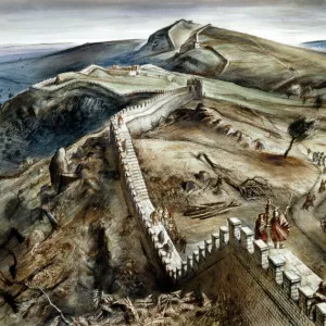
Jigsaw Puzzle : Athelney & Ethandun 878, (1935)
")
")


![]()
Jigsaw Puzzles from Heritage Images
Athelney & Ethandun 878, (1935)
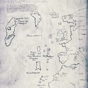
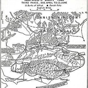
Athelney & Ethandun 878, (1935). Map of part of the west of England (modern Somerset, Dorset, Wiltshire and Hampshire), showing Athelney, which was once the fortress hiding place of King Alfred the Great. From there he went on to defeat the Danes at the Battle of Edington (or Ethandun) in May 878. The map also shows Roman roads and tracks, Alfreds Burhs (Old English fortifications), Danish forts, and significant sites during the period of Viking invasion. From A History of the Anglo-Saxons, Vol. II, by R. H. Hodgkin. [The Clarendon Press, Oxford, 1935]
Heritage Images features heritage image collections
Media ID 15466700
© The Print Collector / Heritage-Images
9th Century Aelfred Alfred I Alfred The Great Anglo Saxon County Dorset Hampshire King Alfred King Alfred The Great King Of Wessex Somerset Wessex Wiltshire
Jigsaw Puzzle (520 Pieces)
Step back in time with our exquisite Athelney & Ethandun 878 jigsaw puzzle from Media Storehouse. This captivating puzzle, featuring an authentic 1935 map of the west of England, invites you on a journey through history. Discover the intricately detailed depiction of modern-day Somerset, Dorset, Wiltshire, and Hampshire, as you piece together the rich history of Athelney and Ethandun. Immerse yourself in the nostalgic charm of this vintage map, perfect for history enthusiasts and puzzle lovers alike. Engage your mind and create a stunning display piece with the Athelney & Ethandun 878 jigsaw puzzle from Media Storehouse.
Made in the USA, 520-piece puzzles measure 16" x 20" (40.6 x 50.8 cm). Every puzzle is meticulously printed on glossy photo paper, which has a strong 1.33 mm thickness. Delivered in a black storage cardboard box, these puzzles are both stylish and practical. (Note: puzzles contain small parts and are not suitable for children under 3 years of age.)
Jigsaw Puzzles are an ideal gift for any occasion
Estimated Product Size is 50.8cm x 40.5cm (20" x 15.9")
These are individually made so all sizes are approximate
Artwork printed orientated as per the preview above, with landscape (horizontal) or portrait (vertical) orientation to match the source image.
FEATURES IN THESE COLLECTIONS
> Animals
> Mammals
> Dogs (Domestic)
> Working
> Great Dane
> Arts
> Artists
> D
> Alfred
> Related Images
> Arts
> Artists
> R
> Roman Roman
> Europe
> Denmark
> Related Images
> Europe
> United Kingdom
> England
> Dorset
> Related Images
> Europe
> United Kingdom
> England
> Hampshire
> Related Images
> Europe
> United Kingdom
> England
> Maps
EDITORS COMMENTS
This print from 1935 depicts a map of Athelney and Ethandun in the west of England, showcasing an important chapter in history. The map showcases the region encompassing modern Somerset, Dorset, Wiltshire, and Hampshire. At its heart lies Athelney, once a fortress that served as King Alfred the Great's secret hideaway. From this strategic location, he launched his successful campaign against the Danish invaders. The intricate details on this map take us back to a time when Roman roads crisscrossed the land and Alfred's Burhs stood as formidable fortifications against enemy forces. Danish forts are also marked on this historical document alongside other significant sites during the Viking invasion period. A visual representation of power struggles and warfare unfolds before our eyes through vibrant colors that bring life to ancient battles fought on these very grounds. This print is taken from R. H. Hodgkin's renowned book "A History of the Anglo-Saxons" published by The Clarendon Press in Oxford. As we gaze upon this piece of artistry, we can't help but marvel at how it encapsulates centuries-old conflicts while reminding us of King Alfred's indomitable spirit and determination to protect his kingdom of Wessex. It serves as a testament to both England's rich heritage and its enduring resilience throughout history.
MADE IN THE USA
Safe Shipping with 30 Day Money Back Guarantee
FREE PERSONALISATION*
We are proud to offer a range of customisation features including Personalised Captions, Color Filters and Picture Zoom Tools
SECURE PAYMENTS
We happily accept a wide range of payment options so you can pay for the things you need in the way that is most convenient for you
* Options may vary by product and licensing agreement. Zoomed Pictures can be adjusted in the Cart.