Jigsaw Puzzle > Asia > Philippines > Maps
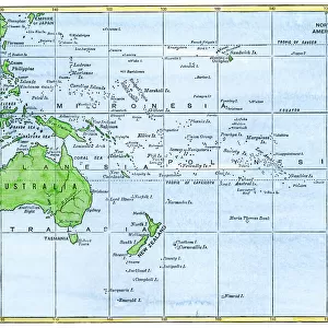
Jigsaw Puzzle : Baie de Manille; Les Terres Du Pacifique, 1914. Creator: Unknown


![]()
Jigsaw Puzzles from Heritage Images
Baie de Manille; Les Terres Du Pacifique, 1914. Creator: Unknown
Baie de Manille; Les Terres Du Pacifique, 1914. From "Grande Geographie Bong Illustree", 1914
Heritage Images features heritage image collections
Media ID 36287670
© The Print Collector/Heritage Images
Archipelago Cartography Island Islands Map Making Mapmaking Philippines
Jigsaw Puzzle (520 Pieces)
Discover the captivating beauty of the past with our Media Storehouse Jigsaw Puzzle featuring the enchanting image, "Baie de Manille; Les Terres Du Pacifique," 1914. This exquisite puzzle, inspired by a vintage map from Grande Geographie Bong Illustree, transports you to a bygone era. Immerse yourself in the rich history and intricate details of this unknown creation from Heritage Images. Solve the puzzle pieces to unveil the stunning depiction of the Pacific territories, and enjoy the therapeutic process of piecing together a piece of history. Perfect for puzzle enthusiasts, history buffs, or anyone seeking a mindful activity, this challenging yet rewarding puzzle is a must-have addition to your collection.
Made in the USA, 520-piece puzzles measure 16" x 20" (40.6 x 50.8 cm). Every puzzle is meticulously printed on glossy photo paper, which has a strong 1.33 mm thickness. Delivered in a black storage cardboard box, these puzzles are both stylish and practical. (Note: puzzles contain small parts and are not suitable for children under 3 years of age.)
Jigsaw Puzzles are an ideal gift for any occasion
Estimated Product Size is 50.8cm x 40.5cm (20" x 15.9")
These are individually made so all sizes are approximate
Artwork printed orientated as per the preview above, with landscape (horizontal) or portrait (vertical) orientation to match the source image.
FEATURES IN THESE COLLECTIONS
> Asia
> Philippines
> Maps
> Asia
> Philippines
> Related Images
> Maps and Charts
> Related Images
Baie de Manille; Les Terres Du Pacifique,
EDITORS COMMENTS
a captivating and enigmatic map print from the early 20th century, showcases the intricate details of the Philippine archipelago as it was known during the French colonial era. The map, created in 1914, is an exquisite example of cartography from a time when exploration and discovery were at the forefront of human curiosity. The print, originally published in "Grande Geographie Bong Illustree," a renowned French geography magazine, is a stunning representation of the islands' geography in vibrant colors and meticulous detail. The map's title, "Baie de Manille; Les Terres Du Pacifique," translates to "Manila Bay; The Lands of the Pacific," highlighting the significance of the Philippines as a vital Pacific Rim country. The map's creator remains unknown, adding to its allure and mystery. Yet, the intricate depiction of the islands' topography, including their names and locations, reveals the extensive knowledge of the region that was available during that time. The map's color palette, with its rich hues and bold lines, not only makes for an aesthetically pleasing piece but also underscores the importance of accurate and detailed cartography in the age of exploration. The "Baie de Manille; Les Terres Du Pacifique" map print is a testament to the rich history of mapmaking and the enduring fascination with the geography of our world. Its intricate details and captivating design continue to captivate and inspire, making it a valuable addition to any collection of historical maps or geography enthusiasts. This print is a window into the past, offering a glimpse into the world as it was known over a century ago, and a reminder of the ongoing quest for knowledge and discovery that drives human curiosity. The unknown creator's masterful work stands as a testament to the power of maps to transport us to new worlds and expand our understanding of the world around us.
MADE IN THE USA
Safe Shipping with 30 Day Money Back Guarantee
FREE PERSONALISATION*
We are proud to offer a range of customisation features including Personalised Captions, Color Filters and Picture Zoom Tools
SECURE PAYMENTS
We happily accept a wide range of payment options so you can pay for the things you need in the way that is most convenient for you
* Options may vary by product and licensing agreement. Zoomed Pictures can be adjusted in the Cart.