Jigsaw Puzzle > Arts > Artists > B > James Bayes
Jigsaw Puzzle : The Civil War in America: scene of operations in eastern Virginia, showing M'Clellan's... 1862. Creator: Unknown


![]()
Jigsaw Puzzles from Heritage Images
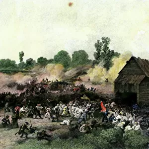
The Civil War in America: scene of operations in eastern Virginia, showing M'Clellan's... 1862. Creator: Unknown
The Civil War in America: scene of operations in eastern Virginia, showing M'Clellan's present position, 1862. Map of...an area of about 20, 000 square miles. About halfway between Richmond and the mouth of the Chickahominy lies the hilly country, where M'Clellan's army is now stationed...seven miles below Richmond, is Fort Darling, where the course of the river is obstructed to prevent the passage of the Federal gun-boats...Five lines of railroad radiate from [Richmond] the capital of Virginia. The Richmond and York River Railroad, which in times of peace connected the city with the aforesaid river, was the line by which M'Clellan supplied his army, and on which his head-quarters at White House were situated until his recent change of front and base of operations. His right wing at one time was extended so far as to rest on the Virginia Central Railway, a line running north from Richmond, just north of the point where it crosses the Chickahominy. This river and the White Oak Swamp, across which his army retreated, lie between the Richmond and York River Railway and the James River. On the south bank of this river...is City Point, where the Federal flotilla is now anchored. This is also the point where the Appomattox flows into the James'. From "Illustrated London News", 1862
Heritage Images features heritage image collections
Media ID 35125359
© The Print Collector/Heritage Images
Atlantic Ocean Blockade Chesapeake Bay General George Mcclellan General Mcclellan George B Mcclellan George Brinton Mcclellan George Mcclellan James River Mcclellan George Mcclellan George B Mcclellan George Brinton Ocean Potomac Potomac River Railway Line Railway Lines Railway Track Railway Tracks River Potomac Train Track United States Navy Us Navy American Civil War Naval Warfare York River
Jigsaw Puzzle (1014 Pieces)
Step back in time with our Media Storehouse Jigsaw Puzzle featuring an iconic image from American history. This captivating puzzle showcases a map of the Eastern Virginia battlefield during the Civil War in 1862. Witness the strategic positioning of General George B. McClellan's forces as they prepared for battle in this intricately detailed, unknown creation. Immerse yourself in history as you piece together the 20,000 square miles of this captivating puzzle, a perfect activity for history enthusiasts and puzzle lovers alike.
Made in the USA, 1014-piece puzzles measure 20" x 30" (50.8 x 76.2 cm). Every puzzle is meticulously printed on glossy photo paper, which has a strong 1.33 mm thickness. Delivered in a black storage cardboard box, these puzzles are both stylish and practical. (Note: puzzles contain small parts and are not suitable for children under 3 years of age.)
Jigsaw Puzzles are an ideal gift for any occasion
Estimated Product Size is 76cm x 50.8cm (29.9" x 20")
These are individually made so all sizes are approximate
Artwork printed orientated as per the preview above, with landscape (horizontal) orientation to match the source image.
FEATURES IN THESE COLLECTIONS
> Arts
> Artists
> B
> James Bayes
> Arts
> Artists
> O
> Oceanic Oceanic
> Arts
> Artists
> R
> George Richmond
> Arts
> Artists
> W
> George Washington
> Arts
> Artists
> W
> George White
> Arts
> Artists
> W
> Georges Washington
> Europe
> United Kingdom
> England
> London
> Towns
> Hampton
> Europe
> United Kingdom
> England
> London
> Towns
> Richmond
> Europe
> United Kingdom
> England
> London
> Transport
> Railway
> Europe
> United Kingdom
> England
> London
> Transport
> Stations
EDITORS COMMENTS
This image, titled "The Civil War in America: scene of operations in eastern Virginia, showing M'Clellan's present position, 1862," is an intriguing and detailed map depicting the strategic landscape of eastern Virginia during the American Civil War. The map covers an area of approximately 20,000 square miles and offers a bird's-eye view of the region around Richmond, the capital city of Virginia. Midway between Richmond and the mouth of the Chickahominy River lies the hilly country where General George B. McClellan's Union Army was stationed during this period. Seven miles south of Richmond, Fort Darling can be found, a fortification built to obstruct the passage of Federal gun-boats on the James River. Five major railroads radiated from Richmond, with the Richmond and York River Railroad being the primary supply line for McClellan's army. His headquarters were situated at White House on this line until his recent change of front and base of operations. The right wing of his army once extended as far as the Virginia Central Railway, a line running north from Richmond, just north of the point where it crosses the Chickahominy River. The Chickahominy River and the White Oak Swamp, across which McClellan's army retreated, lie between the Richmond and York River Railway and the James River. On the south bank of the James River is City Point, where the Federal flotilla was anchored during the Civil War. This is also the point where the Appomattox River flows into the James. The intricate details of this map provide valuable insight into the geographical complexities that shaped the military strategies of both the Union and Confederate forces during the American Civil War.
MADE IN THE USA
Safe Shipping with 30 Day Money Back Guarantee
FREE PERSONALISATION*
We are proud to offer a range of customisation features including Personalised Captions, Color Filters and Picture Zoom Tools
FREE COLORIZATION SERVICE
You can choose advanced AI Colorization for this picture at no extra charge!
SECURE PAYMENTS
We happily accept a wide range of payment options so you can pay for the things you need in the way that is most convenient for you
* Options may vary by product and licensing agreement. Zoomed Pictures can be adjusted in the Cart.