Jigsaw Puzzle > Europe > Latvia > Maps
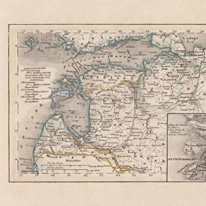
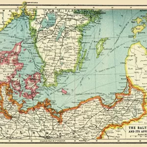
Jigsaw Puzzle : General map of Estonia and Latvia. (Atlas de la Livonie), 1798
, 1798")
, 1798")


![]()
Jigsaw Puzzles from Heritage Images
General map of Estonia and Latvia. (Atlas de la Livonie), 1798
General map of Estonia and Latvia. (Atlas de la Livonie), 1798. Private Collection
Heritage Images features heritage image collections
Media ID 19301195
© Fine Art Images/Heritage Images
1798 Baltic Sea Cartography Courland Estonia Latvia Livonia Copper Engraving Mellin Sea Map
Jigsaw Puzzle (520 Pieces)
Explore the rich history and culture of Estonia and Latvia with our stunning Jigsaw Puzzle from Media Storehouse. Featuring an intricately detailed map of Estonia and Latvia, as depicted in the 1798 "Atlas de la Livonie" by Fine Art Images/Heritage Images, this puzzle is a must-have for history enthusiasts and puzzle lovers alike. Immerse yourself in the beauty of this region's past as you piece together the borders, cities, and landmarks of these two fascinating countries. A perfect activity for families or individuals seeking a challenging and rewarding puzzle experience.
Made in the USA, 520-piece puzzles measure 16" x 20" (40.6 x 50.8 cm). Every puzzle is meticulously printed on glossy photo paper, which has a strong 1.33 mm thickness. Delivered in a black storage cardboard box, these puzzles are both stylish and practical. (Note: puzzles contain small parts and are not suitable for children under 3 years of age.)
Jigsaw Puzzles are an ideal gift for any occasion
Estimated Product Size is 50.8cm x 40.5cm (20" x 15.9")
These are individually made so all sizes are approximate
Artwork printed orientated as per the preview above, with landscape (horizontal) or portrait (vertical) orientation to match the source image.
FEATURES IN THESE COLLECTIONS
> Europe
> Estonia
> Related Images
> Europe
> Latvia
> Related Images
EDITORS COMMENTS
This print showcases the "General map of Estonia and Latvia" from the renowned "Atlas de la Livonie" dating back to 1798. The intricate details and historical significance of this copper engraving make it a true gem in any collection. The map, part of a private collection, offers a fascinating glimpse into the past, depicting the Baltic Sea region with utmost precision. Created by Ludwig August von Mellin (1754-1835), an esteemed German cartographer and graphic artist, this masterpiece beautifully captures the essence of Estonia and Latvia during that era. As we delve into its rich history, we are transported to a time when Courland was still prominent on the map alongside other notable regions such as Livonia. This fine art piece not only serves as an invaluable resource for historians but also evokes curiosity about how these lands have evolved over centuries. The craftsmanship exhibited in this copper engraving is truly remarkable; every stroke tells a story. Its delicate lines and meticulous attention to detail showcase Mellin's expertise in cartography. It is no wonder that this work has found its place among esteemed collections worldwide. Preserved through time, this sea map stands as a testament to our fascination with exploration and discovery. Through Fine Art Images/Heritage Images' lens, we can appreciate both its artistic beauty and historical importance – reminding us of our connection to the past while igniting our imagination for future journeys yet to come.
MADE IN THE USA
Safe Shipping with 30 Day Money Back Guarantee
FREE PERSONALISATION*
We are proud to offer a range of customisation features including Personalised Captions, Color Filters and Picture Zoom Tools
SECURE PAYMENTS
We happily accept a wide range of payment options so you can pay for the things you need in the way that is most convenient for you
* Options may vary by product and licensing agreement. Zoomed Pictures can be adjusted in the Cart.