Jigsaw Puzzle > Arts > Artists > O > Oceanic Oceanic
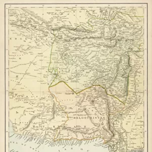
Jigsaw Puzzle : India and the Campaigns of the Middle East, First World War, 1914-1918, (c1920)
")
")


![]()
Jigsaw Puzzles from Heritage Images
India and the Campaigns of the Middle East, First World War, 1914-1918, (c1920)
India and the Campaigns of the Middle East, First World War, 1914-1918, (c1920). Map showing British India coloured pink as part of the British Empire, Afghanistan, Persia, Asia Minor, Arabia, the Arabian Sea and the Bay of Bengal. From " The Great World War: A History", Volume V, edited by Frank A Mumby. [The Gresham Publishing Company Ltd, London, c1920]
Heritage Images features heritage image collections
Media ID 19665667
© The Print Collector/Heritage Images
Afghanistan Arabia Arabian Sea Asia Minor Bartholomew Bartholomew And Co Bartholomew John Son Bay Of Bengal British India British Raj Frank A Frank A Mumby Frank Arthur Frank Arthur Mumby Gresham Publishing Co Ltd Gresham Publishing Company Imperialism Indian Ocean Jg Bartholomew John And Son John Bartholomew And Co John Bartholomew And Son John Bartholomew And Son Ltd Kazakhstan Keystone Archives Mumby Mumby Frank A Mumby Frank Arthur Persia The Great World War A History The Raj Tibet Turkestan Turkey Turkish British Empire
Jigsaw Puzzle (520 Pieces)
Step back in time with Media Storehouse's exquisite jigsaw puzzles, featuring vintage maps from the esteemed John Bartholomew & Son archive. This captivating puzzle presents "India and the Campaigns of the Middle East, First World War, 1914-1918," an intricately detailed map depicting British India in pink as part of the British Empire, along with Afghanistan, Persia, Asia Minor, and Arabia. Immerse yourself in history as you piece together this stunning representation of a pivotal moment in world history. Perfect for history enthusiasts, puzzle collectors, or anyone seeking a challenging and rewarding pastime.
Made in the USA, 520-piece puzzles measure 16" x 20" (40.6 x 50.8 cm). Every puzzle is meticulously printed on glossy photo paper, which has a strong 1.33 mm thickness. Delivered in a black storage cardboard box, these puzzles are both stylish and practical. (Note: puzzles contain small parts and are not suitable for children under 3 years of age.)
Jigsaw Puzzles are an ideal gift for any occasion
Estimated Product Size is 50.8cm x 40.5cm (20" x 15.9")
These are individually made so all sizes are approximate
Artwork printed orientated as per the preview above, with landscape (horizontal) or portrait (vertical) orientation to match the source image.
FEATURES IN THESE COLLECTIONS
> Arts
> Artists
> O
> Oceanic Oceanic
> Asia
> Afghanistan
> Maps
> Asia
> India
> Related Images
> Asia
> Kazakhstan
> Maps
> Asia
> Kazakhstan
> Related Images
> Asia
> Turkey
> Related Images
> Historic
> World War I and II
> World War I
> Historic
> World War I and II
> Maps and Charts
> British Empire Maps
EDITORS COMMENTS
This print titled "India and the Campaigns of the Middle East, First World War, 1914-1918" offers a glimpse into the complex geopolitical landscape of the early 20th century. Created around 1920 by John Bartholomew & Son, it features a map showcasing British India colored in pink as an integral part of the vast British Empire. The map extends beyond India to encompass neighboring regions such as Afghanistan, Persia (modern-day Iran), Asia Minor (Turkey), Arabia, and even parts of Tibet and Turkestan Kazakhstan. The Arabian Sea and Bay of Bengal are also prominently displayed, highlighting their strategic importance during World War I. As we delve into this historical artifact from "The Great World War: A History" edited by Frank A Mumby, we witness the imperialistic ambitions that shaped global politics at that time. The British Raj's influence is evident through its territorial control over vast swaths of land in South Asia. This image not only serves as a visual representation but also sparks contemplation about imperialism and its consequences on nations and peoples. It reminds us how borders were redrawn and alliances formed during one of humanity's most devastating conflicts. Through this photograph print from Heritage Images, we are transported back to an era when empires clashed amidst shifting sands - a poignant reminder of our shared history and its enduring impact on our present world.
MADE IN THE USA
Safe Shipping with 30 Day Money Back Guarantee
FREE PERSONALISATION*
We are proud to offer a range of customisation features including Personalised Captions, Color Filters and Picture Zoom Tools
SECURE PAYMENTS
We happily accept a wide range of payment options so you can pay for the things you need in the way that is most convenient for you
* Options may vary by product and licensing agreement. Zoomed Pictures can be adjusted in the Cart.