Jigsaw Puzzle > Asia > Iran > Lakes > Caspian Sea
Jigsaw Puzzle : Ottoman and Persian, after 1450 A. D. c1915. Creator: Emery Walker Ltd


![]()
Jigsaw Puzzles from Heritage Images
Ottoman and Persian, after 1450 A. D. c1915. Creator: Emery Walker Ltd
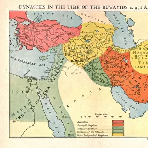
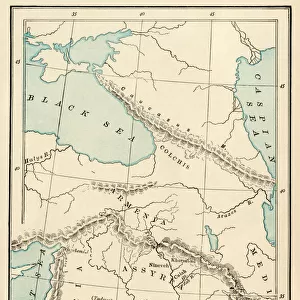
Ottoman and Persian, after 1450 A.D. c1915. Map of empires in the Middle East during the 15th-17th centuries: Ottoman Empire at the accession of Mohammed II, 1451 AD, Additions 1481-1683, Ottoman-Persian boundary c1555. Also showing the eastern Mediterranean, Red Sea, Caspian Sea, Black Sea and Persian Gulf. From " The Caliphs Last Heritage, a short history of the Turkish Empire" by Lt.-Col. Sir Mark Sykes. [Macmillan & Co, London, 1915]
Heritage Images features heritage image collections
Media ID 19658853
© The Print Collector/Heritage Images
6th Baronet Anatolia Arabia Asia Minor Black Sea Boutall Boutall Walker Byzantine Empire Byzantium Caspian Sea Cockerell Cockerell Walker Colonel Sir Tatton Benvenuto Mark Sykes Emery Emery Walker Limited Emery Walker Ltd Iran Iraq Lieutenant Colonel Sir Mark Sykes Macmillan Macmillan And Co Macmillan Publishers Macmillan Publishers Ltd Mahmud Ii Mark Mark Sykes Mediterranean Sea Mehmed Ii Mesopotamia Ottoman Empire Palestine Persia Persian Gulf Persian Gulf Asia Publishers Macmillan Sir Mark Sykes Sykes Sykes Mark Sykes Mark Sir Sykes Tatton Benvenuto Mark Syria Tatton Benvenuto Mark Tatton Benvenuto Mark Sykes Turkey Turkish Walker Walker Amp Walker And Boutall Walker And Cockerell Walker Boutall Walker Cockerell Walker Emery Ltd Mehmed The Conqueror Mohammed Ii
Jigsaw Puzzle (520 Pieces)
Step back in time with Media Storehouse's exquisite Jigsaw Puzzle featuring the intricately detailed map of the Ottoman and Persian Empires during the 15th-17th centuries. This captivating puzzle, created by Emery Walker Ltd, transports you to a world of rich history and cultural exploration. Discover the expansion of the Ottoman Empire under Sultan Mohammed II and the Persian Empire's complex history during this period. With intricately depicted borders, cities, and territories, this puzzle offers a challenging yet rewarding experience for puzzle enthusiasts and history buffs alike. Immerse yourself in the beauty and complexity of this bygone era, and create a stunning display piece for your home or office.
Made in the USA, 520-piece puzzles measure 16" x 20" (40.6 x 50.8 cm). Every puzzle is meticulously printed on glossy photo paper, which has a strong 1.33 mm thickness. Delivered in a black storage cardboard box, these puzzles are both stylish and practical. (Note: puzzles contain small parts and are not suitable for children under 3 years of age.)
Jigsaw Puzzles are an ideal gift for any occasion
Estimated Product Size is 50.8cm x 40.5cm (20" x 15.9")
These are individually made so all sizes are approximate
Artwork printed orientated as per the preview above, with landscape (horizontal) or portrait (vertical) orientation to match the source image.
FEATURES IN THESE COLLECTIONS
> Arts
> Artists
> S
> Syrian Syrian
> Asia
> Iran
> Lakes
> Caspian Sea
> Asia
> Iran
> Related Images
> Asia
> Iraq
> Related Images
> Asia
> Palestine
> Related Images
> Asia
> Syria
> Related Images
EDITORS COMMENTS
This print titled "Ottoman and Persian, after 1450 A. D" takes us back to the vibrant history of the Middle East during the 15th-17th centuries. Created by Emery Walker Ltd in c1915, this map showcases the empires that once dominated the region. The focal point of this image is the Ottoman Empire at its peak under Mohammed II's reign in 1451 AD. It also highlights significant additions made to the empire between 1481 and 1683. The intricate details on this map allow us to trace the Ottoman-Persian boundary around 1555. Beyond depicting political boundaries, this print offers a comprehensive view of various geographical features such as the eastern Mediterranean Sea, Red Sea, Caspian Sea, Black Sea, and Persian Gulf. These bodies of water played crucial roles in shaping trade routes and cultural exchanges during that era. Lt. -Col. Sir Mark Sykes' book "The Caliphs Last Heritage: A Short History of Turkish Empire" serves as an invaluable reference for understanding these historical events depicted on this map. As we delve into this visual representation of history, it becomes evident how interconnected Anatolia (modern-day Turkey), Arabia, Persia (Iran), Iraq, Palestine (Israel), Mesopotamia (Iraq), and other regions were during those times. Emery Walker Ltd has skillfully captured not just a static image but a portal into a bygone era when empires rose and fell against breathtaking landscapes filled with rich cultures and diverse peoples.
MADE IN THE USA
Safe Shipping with 30 Day Money Back Guarantee
FREE PERSONALISATION*
We are proud to offer a range of customisation features including Personalised Captions, Color Filters and Picture Zoom Tools
SECURE PAYMENTS
We happily accept a wide range of payment options so you can pay for the things you need in the way that is most convenient for you
* Options may vary by product and licensing agreement. Zoomed Pictures can be adjusted in the Cart.