Jigsaw Puzzle > Europe > France > Paris > Maps
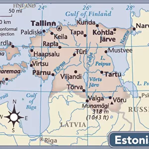
Jigsaw Puzzle : The Partition of Europe under Treaties of Paris, June 1919, (c1920). Creator: Unknown
. Creator: Unknown")
. Creator: Unknown")


![]()
Jigsaw Puzzles from Heritage Images
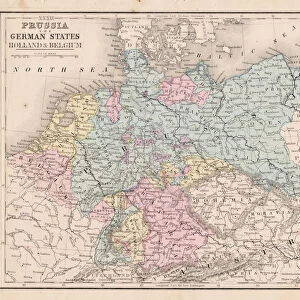
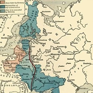
The Partition of Europe under Treaties of Paris, June 1919, (c1920). Creator: Unknown
The Partition of Europe under Treaties of Paris, June 1919, (c1920). Independent States coloured separately; Names of New States shown in Red capitals; Proposed League of Nations Territory; Projected Russian States; Neutral States uncoloured. Europe after the First World War: the new states created included Poland; Yugoslavia; Czechoslovakia; Republic of Estonia, Livonia & Courland; Republic of Lithuania; Republic of White Russia; and Republic of Ukraine. From " The Great World War: A History", Volume IX, edited by Frank A Mumby. [The Gresham Publishing Company Ltd, London, c1920]
Heritage Images features heritage image collections
Media ID 19664910
© The Print Collector/Heritage Images
Balkans Frank A Frank A Mumby Frank Arthur Frank Arthur Mumby Government Gresham Publishing Co Ltd Gresham Publishing Company Independence Independent Keystone Archives League Of Nations Mumby Mumby Frank A Mumby Frank Arthur Organisation Partition Peace Republic State The Great World War A History Treaty Treaty Of Paris Neutral Plebiscite
Jigsaw Puzzle (520 Pieces)
Step back in time with our intricately detailed Media Storehouse Jigsaw Puzzle, featuring The Partition of Europe under the Treaties of Paris, June 1919. This historical puzzle, taken from an original image dating back to the early 1900s, showcases the independent states colored separately with proposed League of Nations territories and new states named in red capitals. Challenge yourself and piece together this captivating puzzle, a perfect addition to any history enthusiast's collection.
Made in the USA, 520-piece puzzles measure 16" x 20" (40.6 x 50.8 cm). Every puzzle is meticulously printed on glossy photo paper, which has a strong 1.33 mm thickness. Delivered in a black storage cardboard box, these puzzles are both stylish and practical. (Note: puzzles contain small parts and are not suitable for children under 3 years of age.)
Jigsaw Puzzles are an ideal gift for any occasion
Estimated Product Size is 50.8cm x 40.5cm (20" x 15.9")
These are individually made so all sizes are approximate
Artwork printed orientated as per the preview above, with landscape (horizontal) or portrait (vertical) orientation to match the source image.
FEATURES IN THESE COLLECTIONS
> Animals
> Mammals
> Cats (Domestic)
> Russian White
> Europe
> Estonia
> Related Images
> Europe
> France
> Paris
> Maps
> Europe
> France
> Paris
> Politics
> Europe
> Lithuania
> Politics
> Europe
> Lithuania
> Posters
> Europe
> Lithuania
> Related Images
The Partition of Europe under Treaties of Paris, June 1919, (c1920)
EDITORS COMMENTS
. This print captures the aftermath of the First World War and the profound changes it brought to Europe. Created by an unknown artist and featured in "The Great World War: A History" this map provides a visual representation of the new political landscape that emerged after the war. In vibrant colors, independent states are delineated separately, with their names highlighted in striking red capitals. The proposed territories for the League of Nations and projected Russian states are also depicted on this comprehensive map. Neutral states remain uncolored, emphasizing their non-aligned status during these transformative times. Amongst the newly created nations showcased on this print are Poland, Yugoslavia, Czechoslovakia, Republics of Estonia, Livonia & Courland, Lithuania, White Russia (Belarus), and Ukraine. These countries symbolize a wave of independence sweeping across Europe as old empires crumbled. The image serves as a testament to both peace efforts through treaties such as those signed in Paris in June 1919 and to ongoing geopolitical challenges faced by nations seeking self-determination. It offers viewers a glimpse into an era where borders were redrawn based on plebiscites and negotiations. As we examine this historical artifact today, it reminds us not only of past conflicts but also highlights how decisions made during this period continue to shape our world today. This photograph print is a valuable resource for understanding the complex dynamics that unfolded during one of history's most significant events – World War I – forever altering European politics and setting forth a new world order.
MADE IN THE USA
Safe Shipping with 30 Day Money Back Guarantee
FREE PERSONALISATION*
We are proud to offer a range of customisation features including Personalised Captions, Color Filters and Picture Zoom Tools
SECURE PAYMENTS
We happily accept a wide range of payment options so you can pay for the things you need in the way that is most convenient for you
* Options may vary by product and licensing agreement. Zoomed Pictures can be adjusted in the Cart.