Jigsaw Puzzle > Europe > Spain > Rivers
Jigsaw Puzzle : Part of South America, 1582


![]()
Jigsaw Puzzles from Heritage Images
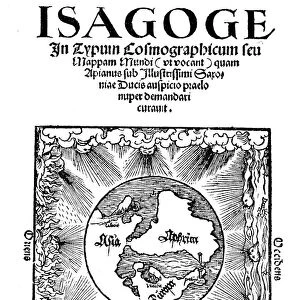
Part of South America, 1582
Part of South America, 1582. A Spanish map, showing the Amazon and the River Plate
Heritage Images features heritage image collections
Media ID 14845522
© Ann Ronan Picture Library / Heritage-Images
Cartography Chart Exploration Imperialism Map Making Navigation River Amazon River Plate Ann Ronan Pictures Rio De La Plata
Jigsaw Puzzle (520 Pieces)
Discover the rich history and geography of South America with the Media Storehouse Jigsaw Puzzle, "Part of South America, 1582." This captivating puzzle features an intricately detailed antique map from Heritage Images, depicting the Amazon and the River Plate. Travel back in time and piece together this historical masterpiece, perfect for history buffs, puzzle enthusiasts, or anyone looking for a challenging and educational pastime. With countless hours of enjoyment, this 1582 Spanish map puzzle is sure to transport you on an unforgettable journey through time. Let the adventure begin!
Made in the USA, 520-piece puzzles measure 16" x 20" (40.6 x 50.8 cm). Every puzzle is meticulously printed on glossy photo paper, which has a strong 1.33 mm thickness. Delivered in a black storage cardboard box, these puzzles are both stylish and practical. (Note: puzzles contain small parts and are not suitable for children under 3 years of age.)
Jigsaw Puzzles are an ideal gift for any occasion
Estimated Product Size is 50.8cm x 40.5cm (20" x 15.9")
These are individually made so all sizes are approximate
Artwork printed orientated as per the preview above, with landscape (horizontal) or portrait (vertical) orientation to match the source image.
FEATURES IN THESE COLLECTIONS
> Europe
> Spain
> Related Images
> Maps and Charts
> Related Images
> Maps and Charts
> Spain
> South America
> Related Images
EDITORS COMMENTS
This print showcases a Spanish map from 1582, offering a glimpse into the exploration and cartography of South America during the 16th century. The intricate details on this map highlight the vastness of the continent, emphasizing two significant geographical features - the Amazon River and the River Plate (also known as Rio de la Plata). As an artifact of colonialism and imperialism, this Spanish map reflects Spain's quest for dominance in South America during that era. It serves as a reminder of how European powers sought to navigate and claim new territories across the globe. The vibrant colors used in this print bring life to the charted rivers, making them stand out against other geographical elements. This visual representation not only aids navigation but also provides valuable information about various countries' locations within South America. Created by an unknown cartographer, this historic piece is part of Ann Ronan Pictures collection. Its existence sheds light on early map-making techniques employed by explorers who ventured into uncharted territories with limited resources. Overall, this print offers viewers an opportunity to delve into history through cartographic artistry. It invites us to appreciate both the beauty and significance of maps as tools for understanding our world while acknowledging their role in shaping historical events such as colonization and exploration.
MADE IN THE USA
Safe Shipping with 30 Day Money Back Guarantee
FREE PERSONALISATION*
We are proud to offer a range of customisation features including Personalised Captions, Color Filters and Picture Zoom Tools
SECURE PAYMENTS
We happily accept a wide range of payment options so you can pay for the things you need in the way that is most convenient for you
* Options may vary by product and licensing agreement. Zoomed Pictures can be adjusted in the Cart.