Jigsaw Puzzle > Europe > Macedonia > Maps
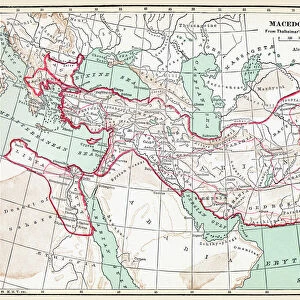
Jigsaw Puzzle : Sur le front des balkans. -- Vue panaoramique du terrain des operations dans les Balkans... 1916. Creator: L. Trinquier


![]()
Jigsaw Puzzles from Heritage Images
Sur le front des balkans. -- Vue panaoramique du terrain des operations dans les Balkans... 1916. Creator: L. Trinquier
Sur le front des balkans. -- Vue panaoramique du terrain des operations dans les Balkans, de Doiran a Florina et a Kastoria. 1916. From "Collection de la Guerre IV. L'Illustration Tome CXLVII. La Guerre Juillet, Aout, Septembre, Octobre, Novembre, Decembre 1916"
Heritage Images features heritage image collections
Media ID 36292229
© The Print Collector/Heritage Images
Balkan Campaign Campaign Cartography Geological Map Lillustration Macedonia Map Making Mapmaking Military Campaign Monastir Macedonia Monastir Offensive
Jigsaw Puzzle (520 Pieces)
Step back in time with our vintage jigsaw puzzle from the Media Storehouse collection. This intriguing puzzle features a panoramic view of the Balkan front during the operations in 1916, as depicted in the original illustration by L. Trinquier from Heritage Images. Immerse yourself in the historical details of this captivating image, originally published in 'L'Illustration Tome CXLVII'. Piece together the rich history of the Balkans and bring this stunning piece of the past into your home. Engage your mind and create a connection with history through the enjoyable process of puzzle solving.
Made in the USA, 520-piece puzzles measure 16" x 20" (40.6 x 50.8 cm). Every puzzle is meticulously printed on glossy photo paper, which has a strong 1.33 mm thickness. Delivered in a black storage cardboard box, these puzzles are both stylish and practical. (Note: puzzles contain small parts and are not suitable for children under 3 years of age.)
Jigsaw Puzzles are an ideal gift for any occasion
Estimated Product Size is 50.8cm x 40.5cm (20" x 15.9")
These are individually made so all sizes are approximate
Artwork printed orientated as per the preview above, with landscape (horizontal) or portrait (vertical) orientation to match the source image.
FEATURES IN THESE COLLECTIONS
> Europe
> Macedonia
> Posters
> Europe
> Macedonia
> Related Images
> Historic
> World War I and II
> World War I
> Historic
> World War I and II
> Maps and Charts
> Geological Map
> Maps and Charts
> North Macedonia
Sur le front des Balkans - A Panoramic View of the Operational Terrain in the Balkans, 1916
EDITORS COMMENTS
is a captivating photographic print by French officer and military cartographer, L. Trinquier. This evocative image offers a glimpse into the complex geography and military landscape of the Balkan Campaign during World War I. The print, titled "Vue panaoramique du terrain des operations dans les Balkans, de Doiran a Florina et a Kastoria," was published in "Collection de la Guerre IV. L'Illustration Tome CXLVII. La Guerre Juillet, Aout, Septembre, Octobre, Novembre, Decembre 1916." The meticulously crafted map covers a vast area, stretching from Doiran to Florina and Kastoria in Macedonia. Trinquier's expertise in mapmaking is evident in the intricate detail and precision of the geological features, military installations, and strategic locations depicted in the image. The print provides an invaluable historical record of the Monastir Offensive, a significant military campaign during the First World War, fought between the Allied forces, primarily British and French, and the Central Powers, primarily Bulgarian and German, in the region. The photographic print, with its striking contrasts of white and black, transports us back to a time of intense conflict and strategic maneuvering. As we examine the intricacies of the map, we can almost hear the distant rumble of artillery and the clash of steel on steel, as the forces of both sides vied for control of this strategically important region. This image is a testament to the rich history of the Balkan Campaign during World War I and the crucial role that military cartography played in shaping the course of the conflict. It serves as a reminder of the complex geopolitical landscape of the region and the enduring legacy of the First World War.
MADE IN THE USA
Safe Shipping with 30 Day Money Back Guarantee
FREE PERSONALISATION*
We are proud to offer a range of customisation features including Personalised Captions, Color Filters and Picture Zoom Tools
SECURE PAYMENTS
We happily accept a wide range of payment options so you can pay for the things you need in the way that is most convenient for you
* Options may vary by product and licensing agreement. Zoomed Pictures can be adjusted in the Cart.