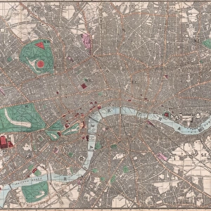
Jigsaw Puzzle : 1775, Mannevillette Map of Trincomalee, Ceylon or Sri Lanka, topography, cartography


![]()
Jigsaw Puzzles from Liszt Collection
1775, Mannevillette Map of Trincomalee, Ceylon or Sri Lanka, topography, cartography
1775, Mannevillette Map of Trincomalee, Ceylon or Sri Lanka
Liszt Collection of nineteenth-century engravings and images to browse and enjoy
Media ID 14004736
© Artokoloro Quint Lox Limited
1775 Antique Map Latitude Longitude Mappa Mundi Old Antique Plan Old Antique View Ols Antique Map Rare Old Maps Topo
Jigsaw Puzzle (520 Pieces)
Discover the rich history of Trincomalee, Ceylon (now Sri Lanka) with our captivating jigsaw puzzle from the Media Storehouse collection. Featuring the 1775 Mannevillette Map of Trincomalee, this intriguing puzzle showcases the topography and cartography of the region as it appeared over 250 years ago. Designed with meticulous attention to detail, this challenging puzzle is a must-have for history enthusiasts, puzzle collectors, and anyone seeking an engaging and educational pastime. Immerse yourself in the past and bring this piece of history to life, one puzzle piece at a time.
Made in the USA, 520-piece puzzles measure 16" x 20" (40.6 x 50.8 cm). Every puzzle is meticulously printed on glossy photo paper, which has a strong 1.33 mm thickness. Delivered in a black storage cardboard box, these puzzles are both stylish and practical. (Note: puzzles contain small parts and are not suitable for children under 3 years of age.)
Jigsaw Puzzles are an ideal gift for any occasion
Estimated Product Size is 50.8cm x 40.5cm (20" x 15.9")
These are individually made so all sizes are approximate
Artwork printed orientated as per the preview above, with landscape (horizontal) or portrait (vertical) orientation to match the source image.
EDITORS COMMENTS
This print showcases a remarkable piece of history - the 1775 Mannevillette Map of Trincomalee, Ceylon (now known as Sri Lanka). With its intricate topography and detailed cartography, this map offers a fascinating glimpse into the past. The artist's skillful illustration captures the geographic features of the region with precision, including mountains, rivers, and coastlines. As we delve into this vintage map, we are transported back in time to an era when exploration and discovery were at their peak. This ancient artifact serves as a testament to mankind's thirst for knowledge about our world. Its yellowed paper and aged appearance add an air of authenticity that further enhances its historical value. The Mannevillette Map not only served as a navigational tool but also provided crucial information for travelers venturing into unknown territories. Its grid system based on latitude and longitude enabled accurate positioning on land or sea. This rare old map is truly a treasure trove of geographical insights. Adorned with decorative elements characteristic of maps from that period, this antique artwork exudes charm and elegance. It reminds us of the importance placed on cartography in documenting our planet's vast wonders. Whether you are an avid collector or simply appreciate the beauty of historical artifacts, this print will transport you to another time - one filled with curiosity and wonderment about our world's rich heritage.
MADE IN THE USA
Safe Shipping with 30 Day Money Back Guarantee
FREE PERSONALISATION*
We are proud to offer a range of customisation features including Personalised Captions, Color Filters and Picture Zoom Tools
SECURE PAYMENTS
We happily accept a wide range of payment options so you can pay for the things you need in the way that is most convenient for you
* Options may vary by product and licensing agreement. Zoomed Pictures can be adjusted in the Cart.