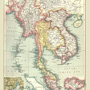
Jigsaw Puzzle : 1850, Perrot Map of Indo-Chine, topography, cartography, geography, land, illustration


![]()
Jigsaw Puzzles from Liszt Collection
1850, Perrot Map of Indo-Chine, topography, cartography, geography, land, illustration
1850, Perrot Map of Indo-Chine
Liszt Collection of nineteenth-century engravings and images to browse and enjoy
Media ID 14007335
© Artokoloro Quint Lox Limited
1850 Antique Map Latitude Longitude Mappa Mundi Old Antique Plan Old Antique View Ols Antique Map Rare Old Maps Topo
Jigsaw Puzzle (520 Pieces)
"Discover the rich history and geography of Indo-China with our captivating jigsaw puzzle from the Media Storehouse Liszt Collection. This intricately detailed puzzle features the 1850 Perrot Map of Indo-Chine, a masterpiece of cartography and topography. Delve into the world of illustration and geography as you piece together this beautiful representation of the region's land and waterways. Ideal for puzzle enthusiasts and history buffs alike, this challenging puzzle offers hours of engaging entertainment and a stunning finished product to display. Embark on an educational adventure with the Media Storehouse 1850 Perrot Map of Indo-Chine jigsaw puzzle."
Made in the USA, 520-piece puzzles measure 16" x 20" (40.6 x 50.8 cm). Every puzzle is meticulously printed on glossy photo paper, which has a strong 1.33 mm thickness. Delivered in a black storage cardboard box, these puzzles are both stylish and practical. (Note: puzzles contain small parts and are not suitable for children under 3 years of age.)
Jigsaw Puzzles are an ideal gift for any occasion
Estimated Product Size is 40.5cm x 50.8cm (15.9" x 20")
These are individually made so all sizes are approximate
Artwork printed orientated as per the preview above, with landscape (horizontal) or portrait (vertical) orientation to match the source image.
EDITORS COMMENTS
This print showcases a remarkable piece of history - the 1850 Perrot Map of Indo-Chine. With its intricate details and exquisite craftsmanship, this map is not only a testament to the artistry of cartography but also an invaluable resource for understanding the topography, geography, and land formations of Indo-China during that era. The Perrot Map takes us on a visual journey through time, offering a glimpse into the ancient world as seen through the eyes of explorers and geographers. Its vintage charm and aged appearance add to its allure, evoking a sense of nostalgia for bygone eras when maps were meticulously hand-drawn with precision and care. As we gaze upon this historical artifact, we are transported back in time to an age where navigation relied heavily on such detailed maps. The grid lines, latitude and longitude markings, along with geometric symbols denoting various regions make it clear that this map was not just decorative but served as an essential tool for travelers embarking on journeys across Indo-China. Whether you are an avid collector or simply fascinated by history's remnants, this rare old map holds immense value. It offers us a window into our past while igniting curiosity about how our world has evolved over centuries. Let this stunning print serve as both a reminder of our rich heritage and an inspiration for future exploration.
MADE IN THE USA
Safe Shipping with 30 Day Money Back Guarantee
FREE PERSONALISATION*
We are proud to offer a range of customisation features including Personalised Captions, Color Filters and Picture Zoom Tools
SECURE PAYMENTS
We happily accept a wide range of payment options so you can pay for the things you need in the way that is most convenient for you
* Options may vary by product and licensing agreement. Zoomed Pictures can be adjusted in the Cart.