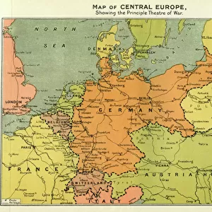
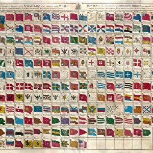
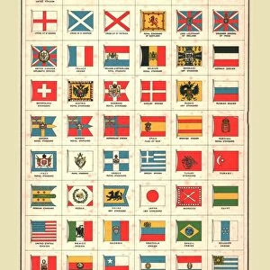
Jigsaw Puzzle : 1864, Johnson Chart of the Flags and National Emblems of the World, topography, cartography


![]()
Jigsaw Puzzles from Liszt Collection
1864, Johnson Chart of the Flags and National Emblems of the World, topography, cartography
1864, Johnson Chart of the Flags and National Emblems of the World
Liszt Collection of nineteenth-century engravings and images to browse and enjoy
Media ID 14007831
© Artokoloro Quint Lox Limited
1864 Antique Map Latitude Longitude Mappa Mundi Old Antique Plan Old Antique View Ols Antique Map Rare Old Maps Topo
Jigsaw Puzzle (520 Pieces)
"Discover the rich history of global emblems and flags with our captivating 1864 Johnson Chart of the Flags and National Emblems of the World jigsaw puzzle from the esteemed Liszt Collection. This intricately detailed puzzle features an exquisite topographical and cartographical representation of the world as it was known during that time, with meticulously rendered illustrations of national flags and emblems. Engage in an enlightening and enjoyable puzzle experience as you piece together this piece of history, making it an excellent addition to any home or office."
Made in the USA, 520-piece puzzles measure 16" x 20" (40.6 x 50.8 cm). Every puzzle is meticulously printed on glossy photo paper, which has a strong 1.33 mm thickness. Delivered in a black storage cardboard box, these puzzles are both stylish and practical. (Note: puzzles contain small parts and are not suitable for children under 3 years of age.)
Jigsaw Puzzles are an ideal gift for any occasion
Estimated Product Size is 50.8cm x 40.5cm (20" x 15.9")
These are individually made so all sizes are approximate
Artwork printed orientated as per the preview above, with landscape (horizontal) or portrait (vertical) orientation to match the source image.
EDITORS COMMENTS
This print showcases the remarkable "1864, Johnson Chart of the Flags and National Emblems of the World". A true masterpiece in topography, cartography, and geography, this vintage illustration takes us on a visual journey through time. The intricate details and artistic precision make it an invaluable piece of historical art. The chart features a grid system with latitude and longitude lines, allowing viewers to navigate through different regions of the world effortlessly. Each flag and national emblem is meticulously illustrated, representing countries from all corners of the globe. It serves as a fascinating snapshot of how nations identified themselves during that era. With its aged appearance and decorative elements, this old map exudes charm and nostalgia. Its presence evokes feelings of discovery and exploration as we imagine early travelers using such maps to navigate uncharted territories. As we gaze upon this rare antique map from the Liszt Collection, we are reminded of our planet's rich history and diverse cultures. It serves as a reminder that even in today's modern age where technology guides our every move, there is still something magical about holding an ancient artifact that once guided explorers across vast oceans.
MADE IN THE USA
Safe Shipping with 30 Day Money Back Guarantee
FREE PERSONALISATION*
We are proud to offer a range of customisation features including Personalised Captions, Color Filters and Picture Zoom Tools
SECURE PAYMENTS
We happily accept a wide range of payment options so you can pay for the things you need in the way that is most convenient for you
* Options may vary by product and licensing agreement. Zoomed Pictures can be adjusted in the Cart.