Jigsaw Puzzle > Arts > Artists > S > John Speed
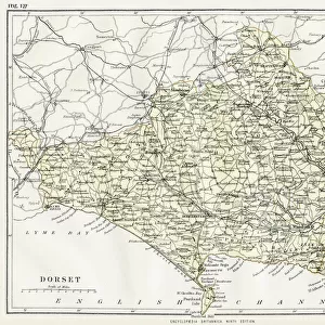
Jigsaw Puzzle : Dorset Historical John Speed 1610 Map


![]()
Jigsaw Puzzles from Map Marketing
Dorset Historical John Speed 1610 Map
A reproduction of John Speeds historical map of the county of Dorset. Originally published as part of his atlas called The Theatre of the Empire of Great Britain in 1610. John Speed ((1552-1629) was a renowned English cartographer, his maps themselves were of high quality and gained a great reputation for being among the best county maps
Media ID 19949213
© Map Marketing Ltd
1610 Historical Map John Speed Dorsetshire
Jigsaw Puzzle (520 Pieces)
Made in the USA, 520-piece puzzles measure 16" x 20" (40.6 x 50.8 cm). Every puzzle is meticulously printed on glossy photo paper, which has a strong 1.33 mm thickness. Delivered in a black storage cardboard box, these puzzles are both stylish and practical. (Note: puzzles contain small parts and are not suitable for children under 3 years of age.)
Jigsaw Puzzles are an ideal gift for any occasion
Estimated Product Size is 50.8cm x 40.5cm (20" x 15.9")
These are individually made so all sizes are approximate
Artwork printed orientated as per the preview above, with landscape (horizontal) or portrait (vertical) orientation to match the source image.
FEATURES IN THESE COLLECTIONS
> Arts
> Artists
> S
> John Speed
> Europe
> United Kingdom
> England
> Dorset
> Related Images
> Maps and Charts
> British Empire Maps
> Maps and Charts
> Early Maps
> Maps and Charts
> Related Images
MADE IN THE USA
Safe Shipping with 30 Day Money Back Guarantee
FREE PERSONALISATION*
We are proud to offer a range of customisation features including Personalised Captions, Color Filters and Picture Zoom Tools
SECURE PAYMENTS
We happily accept a wide range of payment options so you can pay for the things you need in the way that is most convenient for you
* Options may vary by product and licensing agreement. Zoomed Pictures can be adjusted in the Cart.