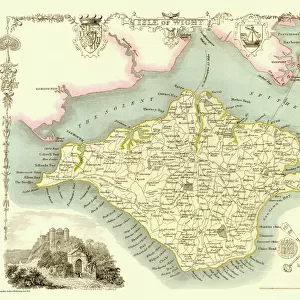
Jigsaw Puzzle > Europe > United Kingdom > England > London > Towns > Welling
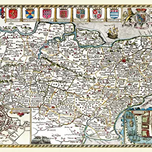
Jigsaw Puzzle : Old County Map of Shropshire 1836 by Thomas Moule


![]()
Jigsaw Puzzles from MapSeeker
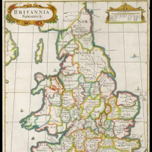
Old County Map of Shropshire 1836 by Thomas Moule
This is a fine decorative reproduction County Map of Shropshire from the First Edition series of Thomas Moule Maps, originally Published in 1836. The well-known series of County Maps which are known as Moules feature beautiful vignette views and were first published in separate sections for each county in 1830-32, they were then published in collected form in a two-volume work: The English Counties Delineated: or a Topographical Description of England: Illustrated by a Complete Series of County Maps by Thomas Moule: London: Published by George Virtue 1836
Welcome to the Mapseeker Image library and enter an historic gateway to one of the largest on-line collections of Historic Maps, Nostalgic Views, Vista's and Panorama's from a World gone by.
Media ID 20348227
© Mapseeker Publishing Ltd
County Map County Map Of England English County Map Historic Map Moule Map Old County Map Old English County Map Old Moule Map Thomas Moule Thomas Moule Map Shropshire
Jigsaw Puzzle (520 Pieces)
Discover the charm of the past with our Old County Map of Shropshire 1836 by Thomas Moule jigsaw puzzle from Media Storehouse. This intricately detailed puzzle features a reproduction of the first edition Thomas Moule Map, published in 1836 by George Virtue from MapSeeker. Travel back in time as you piece together this decorative map of Shropshire, showcasing historical landmarks and intricate cartography. A perfect activity for puzzle enthusiasts and history buffs alike.
Made in the USA, 520-piece puzzles measure 16" x 20" (40.6 x 50.8 cm). Every puzzle is meticulously printed on glossy photo paper, which has a strong 1.33 mm thickness. Delivered in a black storage cardboard box, these puzzles are both stylish and practical. (Note: puzzles contain small parts and are not suitable for children under 3 years of age.)
Jigsaw Puzzles are an ideal gift for any occasion
Estimated Product Size is 40.5cm x 50.8cm (15.9" x 20")
These are individually made so all sizes are approximate
Artwork printed orientated as per the preview above, with landscape (horizontal) or portrait (vertical) orientation to match the source image.
FEATURES IN THESE COLLECTIONS
> Arts
> Artists
> M
> Thomas Moule
> Europe
> United Kingdom
> England
> London
> Towns
> Welling
> Europe
> United Kingdom
> England
> Maps
> Europe
> United Kingdom
> England
> Shropshire
> Related Images
> Europe
> United Kingdom
> England
> Wells
> Maps and Charts
> Early Maps
> Maps and Charts
> Related Images
> MapSeeker
> Maps from the British Isles
> England and Counties PORTFOLIO
EDITORS COMMENTS
This exquisite print showcases an Old County Map of Shropshire from 1836, meticulously crafted by the renowned cartographer Thomas Moule. Part of his esteemed First Edition series, this decorative reproduction captures the essence of historical mapping with its intricate details and captivating vignette views. Originally published as separate sections for each county between 1830 and 1832, Moule's County Maps quickly gained popularity for their exceptional craftsmanship. The English Counties Delineated: or a Topographical Description of England: Illustrated by a Complete Series of County Maps was then released in two volumes in 1836, featuring these remarkable maps collected together. The map itself offers a fascinating glimpse into the past, showcasing Shropshire's rich history and topography. From its rolling hills to charming towns and villages, every corner is beautifully depicted on this historic piece. It serves as both a testament to Moule's skill as a cartographer and an invaluable resource for historians and enthusiasts alike. With George Virtue acting as publisher in London during that time period, this particular edition holds immense value not only due to its historical significance but also because it represents the collaboration between two prominent figures in map-making history. Whether you're an avid collector or simply appreciate the beauty of old maps, this print is sure to captivate your imagination with its timeless charm and detailed representation of Shropshire's past.
MADE IN THE USA
Safe Shipping with 30 Day Money Back Guarantee
FREE PERSONALISATION*
We are proud to offer a range of customisation features including Personalised Captions, Color Filters and Picture Zoom Tools
SECURE PAYMENTS
We happily accept a wide range of payment options so you can pay for the things you need in the way that is most convenient for you
* Options may vary by product and licensing agreement. Zoomed Pictures can be adjusted in the Cart.