Jigsaw Puzzle > Europe > United Kingdom > Scotland > Edinburgh > Edinburgh
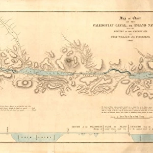
Jigsaw Puzzle : Old Map of the Environs of Edinburgh from the Philips Handy Atlas of 1882


![]()
Jigsaw Puzzles from MapSeeker
Old Map of the Environs of Edinburgh from the Philips Handy Atlas of 1882
PHA011
Welcome to the Mapseeker Image library and enter an historic gateway to one of the largest on-line collections of Historic Maps, Nostalgic Views, Vista's and Panorama's from a World gone by.
Media ID 20348199
Jigsaw Puzzle (520 Pieces)
Discover the charm of the past with our Old Map of the Environs of Edinburgh from the Philips Handy Atlas of 1882 (PHA011) jigsaw puzzle from Media Storehouse. This intricately detailed puzzle features an antique map that offers a captivating glimpse into the history of Scotland's vibrant capital city. With its richly textured terrain, intricate cartography, and historic landmarks, this puzzle is a must-have for puzzle enthusiasts, history buffs, and anyone who loves a good challenge. Bring the past to life in your living room and enjoy the satisfaction of piecing together this beautiful and intriguing puzzle from Media Storehouse.
Made in the USA, 520-piece puzzles measure 16" x 20" (40.6 x 50.8 cm). Every puzzle is meticulously printed on glossy photo paper, which has a strong 1.33 mm thickness. Delivered in a black storage cardboard box, these puzzles are both stylish and practical. (Note: puzzles contain small parts and are not suitable for children under 3 years of age.)
Jigsaw Puzzles are an ideal gift for any occasion
Estimated Product Size is 50.8cm x 40.5cm (20" x 15.9")
These are individually made so all sizes are approximate
Artwork printed orientated as per the preview above, with landscape (horizontal) or portrait (vertical) orientation to match the source image.
FEATURES IN THESE COLLECTIONS
> Europe
> United Kingdom
> Scotland
> Edinburgh
> Edinburgh
> Europe
> United Kingdom
> Scotland
> Edinburgh
> Europe
> United Kingdom
> Scotland
> Lothian
> Edinburgh
> Europe
> United Kingdom
> Scotland
> Maps
> Maps and Charts
> Early Maps
> Maps and Charts
> Related Images
> MapSeeker
> Maps from the British Isles
> Scotland and Counties PORTFOLIO
EDITORS COMMENTS
This print showcases an exquisite piece of history, the "Old Map of the Environs of Edinburgh from the Philips Handy Atlas of 1882". Transporting us back in time, this Scottish environs map offers a fascinating glimpse into the past. With intricate details and delicate craftsmanship, it beautifully captures the essence of Edinburgh's surroundings during that era. As we explore this historic map, we are immersed in a bygone world where bustling streets and charming villages intertwine with lush green landscapes. The carefully drawn boundaries reveal the extent to which Edinburgh's influence stretched beyond its city limits. Every corner holds tales waiting to be discovered – ancient castles guarding their secrets, winding rivers leading to hidden treasures, and quaint towns brimming with life. This old environs map serves as a portal to another time, inviting us to embark on a journey through centuries past. The rich historical significance of this Edinburgh environs map cannot be overstated. It not only provides invaluable insights into urban development but also sheds light on how communities flourished amidst nature's embrace. Whether you are an avid historian or simply captivated by Scotland's allure, this remarkable print is sure to ignite your imagination and spark conversations about our shared heritage
MADE IN THE USA
Safe Shipping with 30 Day Money Back Guarantee
FREE PERSONALISATION*
We are proud to offer a range of customisation features including Personalised Captions, Color Filters and Picture Zoom Tools
SECURE PAYMENTS
We happily accept a wide range of payment options so you can pay for the things you need in the way that is most convenient for you
* Options may vary by product and licensing agreement. Zoomed Pictures can be adjusted in the Cart.