Jigsaw Puzzle > MapSeeker > Maps of Europe > Old Maps of Europe and Small Islands of
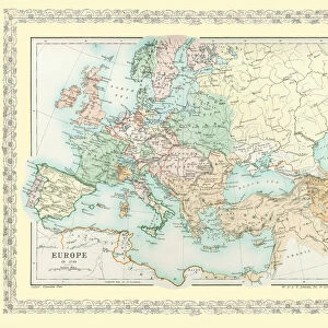
Jigsaw Puzzle : Map of Europe showing how it appeared after the Peace of Westphalia 1648AD


![]()
Jigsaw Puzzles from MapSeeker
Map of Europe showing how it appeared after the Peace of Westphalia 1648AD
EHIST009
Welcome to the Mapseeker Image library and enter an historic gateway to one of the largest on-line collections of Historic Maps, Nostalgic Views, Vista's and Panorama's from a World gone by.
Media ID 20348258
Europe Europe Map Map Of Europe
Jigsaw Puzzle (520 Pieces)
Discover the historical puzzle that brings the past to life with the Media Storehouse Jigsaw Puzzle: MapSeeker EHIST009 - Map of Europe showing how it appeared after the Peace of Westphalia 1648AD. This intricately detailed puzzle features an authentic representation of Europe's political landscape during a pivotal moment in history. Engage in a captivating challenge as you piece together the various territories and borders that emerged from the Peace of Westphalia. Ideal for history enthusiasts, educators, and families, this puzzle offers a fun and engaging way to learn about the past while enjoying the satisfaction of completing a beautiful and meaningful project.
Made in the USA, 520-piece puzzles measure 16" x 20" (40.6 x 50.8 cm). Every puzzle is meticulously printed on glossy photo paper, which has a strong 1.33 mm thickness. Delivered in a black storage cardboard box, these puzzles are both stylish and practical. (Note: puzzles contain small parts and are not suitable for children under 3 years of age.)
Jigsaw Puzzles are an ideal gift for any occasion
Estimated Product Size is 50.8cm x 40.5cm (20" x 15.9")
These are individually made so all sizes are approximate
Artwork printed orientated as per the preview above, with landscape (horizontal) or portrait (vertical) orientation to match the source image.
EDITORS COMMENTS
This print showcases a historical treasure, the "Map of Europe showing how it appeared after the Peace of Westphalia in 1648 AD". A true testament to the transformative power of diplomacy, this map encapsulates a pivotal moment in European history. The Peace of Westphalia marked the end of the devastating Thirty Years' War, which had ravaged Europe for nearly three decades. This meticulously detailed map depicts the territorial boundaries and political landscape that emerged as a result of this landmark peace treaty. It offers an intriguing glimpse into a continent reshaped by negotiations and compromise. As we examine this map, we are transported back to an era when nations were grappling with complex religious conflicts and competing ambitions. The intricate cartography reveals not only borders but also cultural nuances and regional identities that have shaped Europe's rich tapestry. Beyond its historical significance, this print is a visual feast for geography enthusiasts and art lovers alike. Its vibrant colors bring life to each country's distinct shape while capturing our imagination with every contour and coastline. Whether displayed in classrooms or private collections, this MapSeeker photograph invites us to explore Europe's past through its geographical evolution post-Westphalian peace. It serves as both an educational tool and a stunning piece of artwork that sparks curiosity about our shared heritage
MADE IN THE USA
Safe Shipping with 30 Day Money Back Guarantee
FREE PERSONALISATION*
We are proud to offer a range of customisation features including Personalised Captions, Color Filters and Picture Zoom Tools
SECURE PAYMENTS
We happily accept a wide range of payment options so you can pay for the things you need in the way that is most convenient for you
* Options may vary by product and licensing agreement. Zoomed Pictures can be adjusted in the Cart.