Jigsaw Puzzle > Europe > France > Canton > Landes
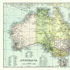
Jigsaw Puzzle : Map of Australia


Jigsaw Puzzles from Mary Evans Picture Library
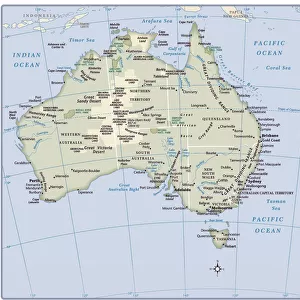
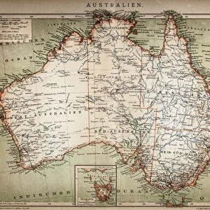
Map of Australia
Map of Australia, showing her natural and industrial resources.
20th century
Mary Evans Picture Library makes available wonderful images created for people to enjoy over the centuries
Media ID 7177883
© Mary Evans Picture Library 2015 - https://copyrighthub.org/s0/hub1/creation/maryevans/MaryEvansPictureID/10507938
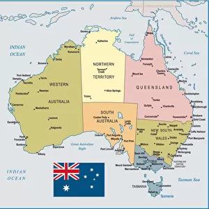
Australasia Maps Pacific Resources Southern Tasmania War Time
Jigsaw Puzzle (1014 Pieces)
Discover the beauty and complexity of Australia with our exquisite jigsaw puzzles from Media Storehouse, featuring the stunning "Map of Australia" by Mary Evans Picture Library/Onslow Auctions Limited. This captivating puzzle showcases a detailed and vibrant representation of Australia's diverse natural and industrial resources from the 20th century. Perfect for puzzle enthusiasts and geography lovers alike, this challenge offers hours of entertainment and a satisfying sense of achievement upon completion. Immerse yourself in the rich history and intricate details of this fascinating puzzle, and bring the land down under into your home.
Made in the USA, 1014-piece puzzles measure 20" x 30" (50.8 x 76.2 cm). Every puzzle is meticulously printed on glossy photo paper, which has a strong 1.33 mm thickness. Delivered in a black storage cardboard box, these puzzles are both stylish and practical. (Note: puzzles contain small parts and are not suitable for children under 3 years of age.)
Jigsaw Puzzles are an ideal gift for any occasion
Estimated Product Size is 76cm x 50.8cm (29.9" x 20")
These are individually made so all sizes are approximate
Artwork printed orientated as per the preview above, with landscape (horizontal) orientation to match the source image.
FEATURES IN THESE COLLECTIONS
> Arts
> Artists
> O
> Oceanic Oceanic
> Europe
> France
> Canton
> Landes
> Maps and Charts
> Related Images
> Oceania
> Australia
> Related Images
EDITORS COMMENTS
This vintage poster showcases a detailed map of Australia from the 20th century, highlighting the vast natural and industrial resources that have shaped the country's history. The map extends from the tropical north, where the Indian Ocean meets the northern tip of Australia, to the arid outback, and the lush green lands of Tasmania in the south. The map's intricate design reveals an abundance of natural resources, including forests, rivers, and mineral deposits. The rich agricultural lands are depicted in verdant green, while the vast deserts and arid regions are shown in earthy browns and reds. The coastal areas, dotted with bays and inlets, are outlined in crisp blue, with the Southern Ocean lapping at the shores. The industrial resources are also prominently featured, with coal mines and oil fields marked in black, and iron and copper mines shown in red and green, respectively. The map also highlights the strategic locations of major ports and shipping lanes, emphasizing Australia's importance as a key player in maritime trade. The poster carries a sense of history, with the map's border adorned with military insignia, reminding us of Australia's involvement in various wars, particularly during the 20th century. The poster's title, "Australia and New Zealand - Map of the Australian Continent and the Islands of the Pacific and Indian Oceans," further emphasizes the geographical significance of the region during that era. This stunning poster is a testament to the rich natural and industrial heritage of Australia and the broader Australasian region. Its intricate design and historical significance make it a must-have for collectors of vintage maps and Australian history.
MADE IN THE USA
Safe Shipping with 30 Day Money Back Guarantee
FREE PERSONALISATION*
We are proud to offer a range of customisation features including Personalised Captions, Color Filters and Picture Zoom Tools
SECURE PAYMENTS
We happily accept a wide range of payment options so you can pay for the things you need in the way that is most convenient for you
* Options may vary by product and licensing agreement. Zoomed Pictures can be adjusted in the Cart.