Jigsaw Puzzle > Europe > France > Canton > Landes
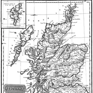
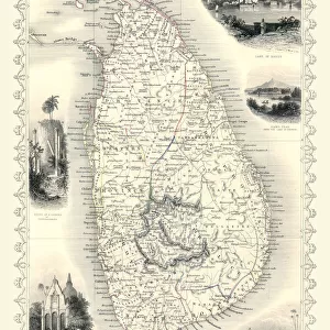
Jigsaw Puzzle : Map of Ceylon showing tea industry plantations


Jigsaw Puzzles from Mary Evans Picture Library
Map of Ceylon showing tea industry plantations
Map of Ceylon (Sri Lanka) showing tea industry plantations. Date: circa 1920
Mary Evans Picture Library makes available wonderful images created for people to enjoy over the centuries
Media ID 14410278
© Mary Evans / Pharcide
Ceylon Growing Lanka Plantation Plantations Sunshine
Jigsaw Puzzle (1014 Pieces)
Discover the rich history and culture of Sri Lanka's tea industry with our captivating jigsaw puzzle from Media Storehouse. This intricately detailed puzzle features a vintage map of Ceylon, now known as Sri Lanka, from circa 1920. The map highlights the extensive tea plantations that have made this country world-renowned for its premium tea production. Immerse yourself in the puzzle's beautiful image, filled with lush greenery, winding roads, and charming tea estates. Perfect for tea lovers, history enthusiasts, or anyone looking for a challenging and rewarding puzzle experience. Dive into the past and explore the fascinating story behind this iconic industry.
Made in the USA, 1014-piece puzzles measure 20" x 30" (50.8 x 76.2 cm). Every puzzle is meticulously printed on glossy photo paper, which has a strong 1.33 mm thickness. Delivered in a black storage cardboard box, these puzzles are both stylish and practical. (Note: puzzles contain small parts and are not suitable for children under 3 years of age.)
Jigsaw Puzzles are an ideal gift for any occasion
Estimated Product Size is 50.8cm x 76cm (20" x 29.9")
These are individually made so all sizes are approximate
Artwork printed orientated as per the preview above, with portrait (vertical) orientation to match the source image.
FEATURES IN THESE COLLECTIONS
> Asia
> India
> Related Images
> Asia
> Sri Lanka
> Related Images
> Europe
> France
> Canton
> Landes
> Maps and Charts
> British Empire Maps
> Maps and Charts
> India
> Maps and Charts
> Related Images
EDITORS COMMENTS
1. Title: "Map of Ceylon (Sri Lanka) in the 1920s: A Visual Testament to the British Tea Industry's Colonial Expansion" This map print, dated circa 1920, offers a glimpse into the British colonial influence on Ceylon (now Sri Lanka) during the 1920s, with a focus on the burgeoning tea industry. The map, bathed in a warm, sunlit hue, beautifully illustrates the island nation's geography, with its intricate network of tea plantations spread across the lush, green highlands. The map's vibrant colors – a rich tapestry of blue seas, sun-kissed land, and the verdant greens of the tea plantations – evoke a sense of tranquility and prosperity. The island's strategic location in the Indian Ocean, marked by the presence of ships and shipping lanes, underscores its importance as a vital trading hub during the colonial era. The British Empire's influence is evident in the map's meticulous detailing, with the tea plantations neatly demarcated and labeled, showcasing the extensive reach of the tea industry. The map serves as a testament to the British colonial endeavor in Ceylon, which transformed the island into a major global tea producer. The map's visual appeal extends beyond its historical significance, making it an intriguing addition to any collection focused on colonial history, geography, or the tea industry. Its evocative imagery of sunshine, sea, land, and the promise of a cup of fine Ceylon tea, continues to resonate with us today, offering a glimpse into a bygone era.
MADE IN THE USA
Safe Shipping with 30 Day Money Back Guarantee
FREE PERSONALISATION*
We are proud to offer a range of customisation features including Personalised Captions, Color Filters and Picture Zoom Tools
SECURE PAYMENTS
We happily accept a wide range of payment options so you can pay for the things you need in the way that is most convenient for you
* Options may vary by product and licensing agreement. Zoomed Pictures can be adjusted in the Cart.