Jigsaw Puzzle > Maps and Charts > British Empire Maps
Jigsaw Puzzle : Map of the British Empire


Jigsaw Puzzles from Mary Evans Picture Library
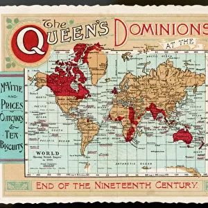
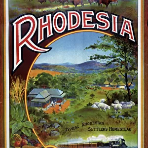
Map of the British Empire
The Howard Vincent map of the British Empire, 1897 Date: 1897
Mary Evans Picture Library makes available wonderful images created for people to enjoy over the centuries
Media ID 7403911
© Mary Evans Picture Library 2015 - https://copyrighthub.org/s0/hub1/creation/maryevans/MaryEvansPictureID/10474598
Jigsaw Puzzle (520 Pieces)
Discover the rich history of the British Empire with our captivating jigsaw puzzles from Media Storehouse. This intricately detailed puzzle features an iconic map of the British Empire, as depicted in the Howard Vincent map of 1897, obtained from Mary Evans Prints Online. Immerse yourself in the intricacies of this historical puzzle, perfect for puzzle enthusiasts and history buffs alike. Engage your mind, challenge your problem-solving skills, and bring this piece of history to life in the comfort of your own home. Experience the joy of completing a high-quality jigsaw puzzle, and transport yourself back in time with every piece you place. Make your next puzzle-solving adventure an educational and enjoyable journey with Media Storehouse.
Made in the USA, 520-piece puzzles measure 16" x 20" (40.6 x 50.8 cm). Every puzzle is meticulously printed on glossy photo paper, which has a strong 1.33 mm thickness. Delivered in a black storage cardboard box, these puzzles are both stylish and practical. (Note: puzzles contain small parts and are not suitable for children under 3 years of age.)
Jigsaw Puzzles are an ideal gift for any occasion
Estimated Product Size is 50.8cm x 40.5cm (20" x 15.9")
These are individually made so all sizes are approximate
Artwork printed orientated as per the preview above, with landscape (horizontal) orientation to match the source image.
FEATURES IN THESE COLLECTIONS
> Maps and Charts
> British Empire Maps
> Maps and Charts
> Related Images
> Maps and Charts
> World
> Popular Themes
> Maps and Charts
> Mary Evans Prints Online
> National Archives
EDITORS COMMENTS
1. Title: "The Reach of the British Empire: A Glimpse into the 19th Century's Global Power Dynamics through the Howard Vincent Map of 1897" This image presents the Howard Vincent Map of the British Empire, a testament to the vast territorial expansion and influence of the British Empire during the 19th century. Dated 1897, this map offers a striking visual representation of the world as it was then known, with the British Empire's dominion stretching across continents and oceans. The intricate details of this map reveal the extensive reach of the British Empire, which had grown significantly during the Victorian era through a combination of colonization, diplomacy, and military conquest. The map includes annotations detailing the various territories under British rule, from the self-governing dominions like Canada and Australia to the protectorates and colonies scattered across Africa, Asia, and the Pacific. The Howard Vincent Map of the British Empire is an essential historical document, providing valuable insights into the geopolitical landscape of the late 19th century. It serves as a reminder of the profound impact the British Empire had on the world during this period, shaping the political, economic, and cultural landscape in numerous ways. This map also offers a fascinating perspective on the global power dynamics of the time, with the British Empire standing as a dominant force alongside other major European powers. The intricate plan of territories, borders, and annotations on this map offers a glimpse into the complex web of international relations that characterized the late 19th century. In summary, this image of the Howard Vincent Map of the British Empire offers a unique window into the world of the late 19th century, revealing the vast territorial reach and global influence of the British Empire during this transformative era.
MADE IN THE USA
Safe Shipping with 30 Day Money Back Guarantee
FREE PERSONALISATION*
We are proud to offer a range of customisation features including Personalised Captions, Color Filters and Picture Zoom Tools
SECURE PAYMENTS
We happily accept a wide range of payment options so you can pay for the things you need in the way that is most convenient for you
* Options may vary by product and licensing agreement. Zoomed Pictures can be adjusted in the Cart.