Jigsaw Puzzle > Animals > Mammals > Muridae > Western Mouse
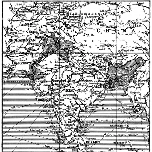
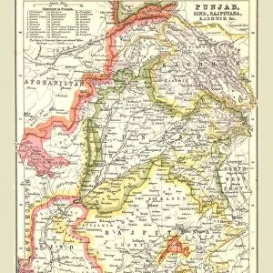
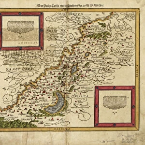
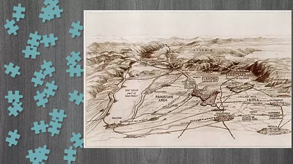
Jigsaw Puzzle : Partition. Map of East and West Punjab


![]()
Jigsaw Puzzles from Mary Evans Picture Library
Partition. Map of East and West Punjab
The areas of the Western and Eastern Punjab where there were many outbreaks of violence between Muslims, Sikhs and Hindus following Partition and the creation of modern India and Pakistan
Mary Evans Picture Library makes available wonderful images created for people to enjoy over the centuries
Media ID 4410760
© Mary Evans Picture Library 2015 - https://copyrighthub.org/s0/hub1/creation/maryevans/MaryEvansPictureID/10238531
1947 Creation Exodus Hindu Hindus Muslim Muslims Pakistan Partition Punjab Sikh Sikhs Violence
Jigsaw Puzzle (1014 Pieces)
Discover the historical complexity of the past with our captivating "Partition. Map of East and West Punjab" jigsaw puzzle from Media Storehouse. This intriguing puzzle, featuring an image sourced from Rights Managed at Mary Evans Prints Online, offers a unique look into the turbulent events that shaped modern India and Pakistan. As you piece together the borders of the Eastern and Western Punjab regions, you'll be transported back in time to the momentous period of Partition. This intricately designed puzzle invites you to explore the rich history of this region, where religious tensions between Muslims, Sikhs, and Hindus led to widespread violence and the creation of two separate nations. Embrace the challenge of fitting each piece into place, uncovering the intricate details of the map, and ultimately, gaining a deeper understanding of this pivotal moment in history. The Media Storehouse "Partition. Map of East and West Punjab" jigsaw puzzle is more than just a fun activity – it's an educational experience that will engage and captivate history enthusiasts of all ages.
Made in the USA, 1014-piece puzzles measure 20" x 30" (50.8 x 76.2 cm). Every puzzle is meticulously printed on glossy photo paper, which has a strong 1.33 mm thickness. Delivered in a black storage cardboard box, these puzzles are both stylish and practical. (Note: puzzles contain small parts and are not suitable for children under 3 years of age.)
Jigsaw Puzzles are an ideal gift for any occasion
Estimated Product Size is 76cm x 50.8cm (29.9" x 20")
These are individually made so all sizes are approximate
Artwork printed orientated as per the preview above, with landscape (horizontal) orientation to match the source image.
FEATURES IN THESE COLLECTIONS
> Animals
> Mammals
> Muridae
> Western Mouse
> Asia
> India
> Related Images
> Asia
> Pakistan
> Related Images
> Maps and Charts
> Early Maps
> Maps and Charts
> India
> Maps and Charts
> Related Images
EDITORS COMMENTS
This evocative map print depicts the Eastern and Western regions of Punjab on the eve of the momentous event that would forever alter the political and demographic landscape of the Indian subcontinent. The year was 1947, and the partition of India and Pakistan was imminent. The map highlights the areas of intense violence and displacement that erupted between Muslims, Sikhs, and Hindus in the wake of this historical division. The Eastern and Western Punjab, shown in vibrant shades of red and green, were the epicenters of the chaos that ensued following the creation of modern India and Pakistan. The map serves as a stark reminder of the exodus that took place as millions of people were forced to leave their homes and cross the newly drawn borders, often facing unimaginable hardships and violence along the way. The map does not merely represent a geographical boundary but a tragic chapter in the history of the Indian subcontinent. The partition of Punjab led to the displacement of over 14 million people, making it one of the largest mass migrations in human history. The violence that erupted during this period claimed the lives of hundreds of thousands of people, leaving deep scars on the collective psyche of the region. This map print serves as a poignant reminder of the human cost of political divisions and the importance of understanding the complex historical context that shaped the modern nations of India and Pakistan. It is a testament to the resilience and determination of the people of the subcontinent, who have continued to rebuild their lives and communities in the face of adversity.
MADE IN THE USA
Safe Shipping with 30 Day Money Back Guarantee
FREE PERSONALISATION*
We are proud to offer a range of customisation features including Personalised Captions, Color Filters and Picture Zoom Tools
SECURE PAYMENTS
We happily accept a wide range of payment options so you can pay for the things you need in the way that is most convenient for you
* Options may vary by product and licensing agreement. Zoomed Pictures can be adjusted in the Cart.