Jigsaw Puzzle > Europe > France > Canton > Landes
Jigsaw Puzzle : EXPL2A-00164


![]()
Jigsaw Puzzles from North Wind
EXPL2A-00164
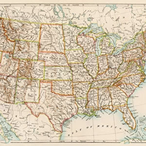
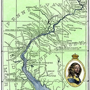
Map of the United States at the close of the American Revolution, 1783.
Printed color lithograph of a 19th-century illustration
North Wind Picture Archives brings history to life with stock images and hand-colored illustrations
Media ID 5877412
© North Wind Picture Archives
13 Colonies 1700s 1780s 1783 18th Century American Revolution Claim East Eastern Land Northwest Territory Revolutionary War Territory Thirteen Colonies
Jigsaw Puzzle (1014 Pieces)
Discover history like never before with Media Storehouse's Jigsaw Puzzle, featuring the intricately detailed map of the United States at the close of the American Revolution, in 1783. This captivating puzzle, represented by item EXPL2A-00164 from North Wind Picture Archives, invites you on a journey back in time. Immerse yourself in the rich history of the American Revolution as you piece together this stunning 19th-century illustration. With vibrant colors and intricate details, this puzzle promises a challenging yet rewarding experience for puzzle enthusiasts of all ages. Engage in a fun and educational activity while creating a beautiful keepsake to proudly display in your home. Let the adventure begin!
Made in the USA, 1014-piece puzzles measure 20" x 30" (50.8 x 76.2 cm). Every puzzle is meticulously printed on glossy photo paper, which has a strong 1.33 mm thickness. Delivered in a black storage cardboard box, these puzzles are both stylish and practical. (Note: puzzles contain small parts and are not suitable for children under 3 years of age.)
Jigsaw Puzzles are an ideal gift for any occasion
Estimated Product Size is 50.8cm x 76cm (20" x 29.9")
These are individually made so all sizes are approximate
Artwork printed orientated as per the preview above, with portrait (vertical) orientation to match the source image.
FEATURES IN THESE COLLECTIONS
> Europe
> France
> Canton
> Landes
> Maps and Charts
> Related Images
> North America
> Related Images
> North Wind Picture Archives
> American history
> North Wind Picture Archives
> Maps
EDITORS COMMENTS
This print showcases a historic map of the United States at the close of the American Revolution in 1783. The intricate details and vibrant colors of this printed lithograph bring to life a 19th-century illustration, offering us a glimpse into the past. The map depicts the eastern territory of North America, highlighting the thirteen colonies that would eventually become the foundation for our great nation. It serves as a visual representation of an era marked by struggle and triumph - the Revolutionary War and its aftermath. As we examine this vintage artwork, we can't help but imagine how these lands were once claimed by different European powers before being united under one flag. This piece transports us back to a time when each state was still finding its place within this newly formed country. With its rich historical significance, this print is not only a work of art but also an educational tool that allows us to explore our roots and understand how our nation evolved over time. It reminds us of those who fought for independence and laid down the foundations upon which we stand today. Whether you are an enthusiast of American history or simply appreciate beautiful illustrations from centuries past, this print is sure to captivate your imagination with its portrayal of post-revolutionary America.
MADE IN THE USA
Safe Shipping with 30 Day Money Back Guarantee
FREE PERSONALISATION*
We are proud to offer a range of customisation features including Personalised Captions, Color Filters and Picture Zoom Tools
SECURE PAYMENTS
We happily accept a wide range of payment options so you can pay for the things you need in the way that is most convenient for you
* Options may vary by product and licensing agreement. Zoomed Pictures can be adjusted in the Cart.