Jigsaw Puzzle > Arts > Artists > O > Oceanic Oceanic
Jigsaw Puzzle : Iceland map, 1800s


Jigsaw Puzzles from North Wind
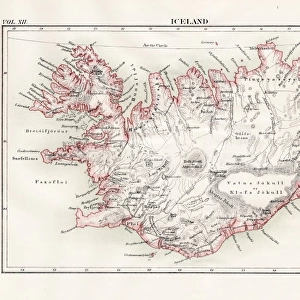
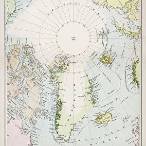
Iceland map, 1800s
Map of Iceland, 1870s.
Printed color lithograph reproduction of a 19th-century illustratioin
North Wind Picture Archives brings history to life with stock images and hand-colored illustrations
Media ID 5882584
© North Wind Picture Archives
Atlantic Atlantic Ocean Island Ocean Fjord North Atlantic
Jigsaw Puzzle (1014 Pieces)
Discover the captivating history of Iceland with Media Storehouse's Jigsaw Puzzle featuring an intricately detailed, 1870s map of the island nation. This beautifully printed color lithograph reproduction, sourced from the North Wind Picture Archives, transports you back in time, inviting you to piece together the rich history and geography of Iceland during the 19th century. Immerse yourself in the puzzle-solving adventure, and bring a piece of the past into your home. Perfect for history buffs, puzzle enthusiasts, or anyone seeking a challenging and rewarding pastime.
Made in the USA, 1014-piece puzzles measure 20" x 30" (50.8 x 76.2 cm). Every puzzle is meticulously printed on glossy photo paper, which has a strong 1.33 mm thickness. Delivered in a black storage cardboard box, these puzzles are both stylish and practical. (Note: puzzles contain small parts and are not suitable for children under 3 years of age.)
Jigsaw Puzzles are an ideal gift for any occasion
Estimated Product Size is 76cm x 50.8cm (29.9" x 20")
These are individually made so all sizes are approximate
Artwork printed orientated as per the preview above, with landscape (horizontal) orientation to match the source image.
FEATURES IN THESE COLLECTIONS
> Arts
> Artists
> O
> Oceanic Oceanic
> Europe
> Iceland
> Related Images
> Maps and Charts
> Related Images
> Popular Themes
> Maps and Charts
> Popular Themes
> North Island
> North Wind Picture Archives
> Maps
EDITORS COMMENTS
This vintage print takes us back to the 19th century, offering a glimpse into Iceland's rich history and natural beauty. The meticulously detailed map showcases the island's unique geography with its jagged coastlines, fjords, and vast stretches of ocean. Printed in vibrant colors using lithography techniques, this reproduction brings to life an illustration that was originally crafted over a century ago. The map not only serves as a visual guide but also evokes a sense of heritage and tradition. It reminds us of Iceland's deep connection to its past and the resilience of its people who have thrived amidst the harsh North Atlantic conditions for centuries. As we explore this artwork, we can almost feel ourselves transported to another time when cartographers painstakingly charted these lands by hand. The artistry displayed in this piece is truly remarkable; it captures both the scientific accuracy required for mapping purposes and an artistic flair that elevates it beyond mere documentation. This fusion of science and art makes it more than just a map – it becomes an exquisite work of historical illustration. Whether you are fascinated by Iceland's history or simply appreciate beautiful artwork from yesteryears, this print offers a window into both worlds. Displaying this piece will undoubtedly spark conversations about exploration, cultural heritage, and the enduring allure of maps as gateways to discovery.
MADE IN THE USA
Safe Shipping with 30 Day Money Back Guarantee
FREE PERSONALISATION*
We are proud to offer a range of customisation features including Personalised Captions, Color Filters and Picture Zoom Tools
SECURE PAYMENTS
We happily accept a wide range of payment options so you can pay for the things you need in the way that is most convenient for you
* Options may vary by product and licensing agreement. Zoomed Pictures can be adjusted in the Cart.