Jigsaw Puzzle > Arts > Artists > H > Jodocus Hondius
Jigsaw Puzzle : 17th century map of the New World


![]()
Jigsaw Puzzles from Science Photo Library
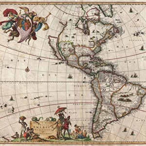
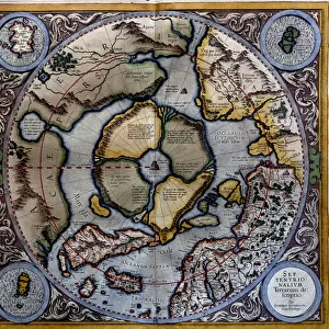
17th century map of the New World
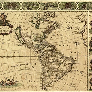
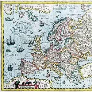
Western Hemisphere, 17th century Dutch map. This shows the New World that was being discovered by Europeans exploring the Western Hemisphere of the Earth. The continents of North and South America (upper centre & lower right) are distorted because they had not yet been accurately mapped. In this map, detailed coastal names are provided and the western coast of South America has been corrected from previous maps. North Americas western coast is still greatly distorted. At lower left is an artwork of the indigenous people of Brazil, while ships and sea monsters decorate the oceans. This 1628 map, published by Jodocus Hondius, continued the earlier work of Gerard Mercator
Science Photo Library features Science and Medical images including photos and illustrations
Media ID 6351601
© GEORGETTE DOUWMA/SCIENCE PHOTO LIBRARY
17th Century Aboriginal Age Of Discovery Ancient Cartography Distorted Distortion Dutch Earth Science Exploration Exploring Illustrated Inaccurate Incomplete Indigenous Latin Mapping Maps Mercator New World Sciences Seventeenth South 1628 Aboriginals Gerard Gerardus Hondius Jodocus Native Americans Western Hemisphere
Jigsaw Puzzle (520 Pieces)
Discover the wonders of the past with our Media Storehouse Jigsaw Puzzles featuring the captivating 17th century map of the New World by Science Photo Library. This intricately detailed puzzle showcases an intriguing glimpse into the Western Hemisphere as it was being explored by European navigators. With the Dutch map as your guide, piece together the rich history of the New World, uncovering the unknown territories and hidden treasures of a bygone era. Engage your mind and transport yourself on a journey of discovery with our Media Storehouse Jigsaw Puzzles.
Made in the USA, 520-piece puzzles measure 16" x 20" (40.6 x 50.8 cm). Every puzzle is meticulously printed on glossy photo paper, which has a strong 1.33 mm thickness. Delivered in a black storage cardboard box, these puzzles are both stylish and practical. (Note: puzzles contain small parts and are not suitable for children under 3 years of age.)
Jigsaw Puzzles are an ideal gift for any occasion
Estimated Product Size is 50.8cm x 40.5cm (20" x 15.9")
These are individually made so all sizes are approximate
Artwork printed orientated as per the preview above, with landscape (horizontal) or portrait (vertical) orientation to match the source image.
FEATURES IN THESE COLLECTIONS
> Animals
> Mammals
> Muridae
> Western Mouse
> Arts
> Artists
> H
> Jodocus Hondius
> Arts
> Artists
> M
> Gerardus Mercator
> Arts
> Artists
> O
> Oceanic Oceanic
> Arts
> Photorealistic artworks
> Detailed art pieces
> Masterful detailing in art
> Europe
> Related Images
> Maps and Charts
> Early Maps
> Maps and Charts
> Gerardus Mercator's Cartographic
> Maps and Charts
> Related Images
> Maps and Charts
> World
EDITORS COMMENTS
This 17th century Dutch map of the New World takes us back to a time when European explorers were venturing into the unknown Western Hemisphere. Published in 1628 by Jodocus Hondius, it builds upon the earlier work of Gerard Mercator, showcasing both accuracy and distortion characteristic of its era. The continents of North and South America dominate the upper center and lower right sections, but their shapes are noticeably distorted due to incomplete mapping at that time. However, this map marks an improvement as it corrects previous errors on the western coast of South America while still depicting North America's western coast with significant distortion. What makes this print truly fascinating is its attention to detail. Coastal names are meticulously labeled, providing insight into early cartography practices. The oceans come alive with beautifully illustrated ships sailing through uncharted waters alongside mythical sea monsters lurking beneath the waves. Adding cultural significance to this historical document is an artwork featuring indigenous people from Brazil in the lower left corner. This inclusion highlights not only Europe's exploration but also acknowledges native populations encountered during these voyages. As we gaze upon this ancient piece of artistry and science combined, we are reminded of how far our understanding has evolved since then. It serves as a testament to humanity's insatiable curiosity for discovery during what was known as the Age of Exploration.
MADE IN THE USA
Safe Shipping with 30 Day Money Back Guarantee
FREE PERSONALISATION*
We are proud to offer a range of customisation features including Personalised Captions, Color Filters and Picture Zoom Tools
SECURE PAYMENTS
We happily accept a wide range of payment options so you can pay for the things you need in the way that is most convenient for you
* Options may vary by product and licensing agreement. Zoomed Pictures can be adjusted in the Cart.