Jigsaw Puzzle > Sheffield City Archives > Maps and Plans > John Speed's County Maps, 1611
Jigsaw Puzzle : John Speeds map of Rutland, 1611


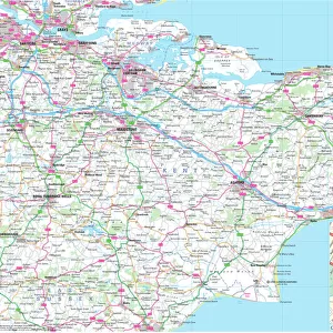
![]()
Jigsaw Puzzles from Sheffield City Archives
John Speeds map of Rutland, 1611
Image from Theatre of the Empire of Great Britaine presenting an exact geography of the Kingdomes of Ireland, Scotland, Ireland, and the Iles adioyning with The Shires, Hundreds, Cities and Shire Towns, within ye Kingdome of England, divided and described by John Speed (original at Sheffield Libraries: 914.2 SQ).
Note this image is of a genuine 400-year-old map from a tightly bound volume. It shows some wear and tear as well as the binding in the middle of the image
Sheffield City Archives and Local Studies Library has an unrivalled collection of images of Sheffield, England
Media ID 26401408
© Sheffield City Council - All Rights Reserved
Jigsaw Puzzle (520 Pieces)
Discover the captivating history of Rutland with our Media Storehouse Jigsaw Puzzle featuring John Speeds' Map of Rutland, 1611. This intricately detailed puzzle, derived from the Theatre of the Empire of Great Britaine, offers a unique and educational experience. Immerse yourself in the rich heritage of Rutland as you piece together the history of the shires, hundreds, and adjoining isles. With each puzzle piece, you'll uncover a piece of history, making this puzzle not just a pastime but an exciting journey through time. Engage your mind and transport yourself back to the 17th century with this captivating jigsaw puzzle.
Made in the USA, 520-piece puzzles measure 16" x 20" (40.6 x 50.8 cm). Every puzzle is meticulously printed on glossy photo paper, which has a strong 1.33 mm thickness. Delivered in a black storage cardboard box, these puzzles are both stylish and practical. (Note: puzzles contain small parts and are not suitable for children under 3 years of age.)
Jigsaw Puzzles are an ideal gift for any occasion
Estimated Product Size is 50.8cm x 40.5cm (20" x 15.9")
These are individually made so all sizes are approximate
Artwork printed orientated as per the preview above, with landscape (horizontal) or portrait (vertical) orientation to match the source image.
EDITORS COMMENTS
This print showcases John Speed's map of Rutland, dating back to 1611. Extracted from the renowned "Theatre of the Empire of Great Britaine" this image offers a glimpse into the exact geography of England during that era. Preserved within Sheffield Libraries, this genuine 400-year-old map is a testament to both its historical significance and enduring beauty. Despite its age, the wear and tear evident on the map only adds to its charm and authenticity. The binding in the middle serves as a tangible reminder of how these maps were once cherished possessions, carefully stored within tightly bound volumes. As we admire this photograph, we are transported back in time to an era when cartography was still evolving and exploration was at its peak. John Speed's meticulous attention to detail is evident in every inch of this map. From shires to hundreds, cities to shire towns, he masterfully captures the essence of Rutland's landscape with precision and accuracy. This snapshot allows us to appreciate not only his skill as a cartographer but also provides valuable insights into England's past. As we gaze upon this remarkable piece from Sheffield City Archives, let us marvel at how far our understanding of geography has come since 1611 while simultaneously cherishing these remnants from centuries gone by.
MADE IN THE USA
Safe Shipping with 30 Day Money Back Guarantee
FREE PERSONALISATION*
We are proud to offer a range of customisation features including Personalised Captions, Color Filters and Picture Zoom Tools
SECURE PAYMENTS
We happily accept a wide range of payment options so you can pay for the things you need in the way that is most convenient for you
* Options may vary by product and licensing agreement. Zoomed Pictures can be adjusted in the Cart.