Jigsaw Puzzle > Maps and Charts > Related Images
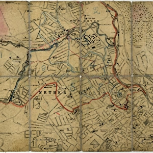
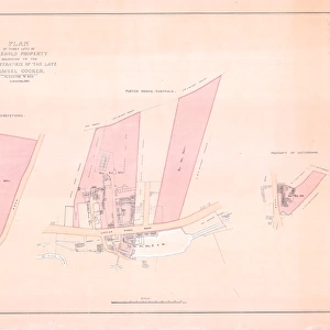
Jigsaw Puzzle : Plan of that part of the Halifax Turnpike Road between Sheffield and Penistone by W. and J. Fairbank, 1825


![]()
Jigsaw Puzzles from Sheffield City Archives
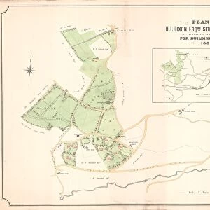
Plan of that part of the Halifax Turnpike Road between Sheffield and Penistone by W. and J. Fairbank, 1825
Plan of that part of the Halifax Turnpike Road between Sheffield and Peniston, with the proposed Diversions and Branch from the same: shewing also the Langset Turnpike Road from near Wadsley Bridge to Deep Car; with the proposed continuation from thence to the first mentioned Turnpike Road, near Thurgoland Bridge.Scale 2.6 inches : 3 miles.Size 42 x 34 cm.Original at Local Studies E5S
Sheffield City Archives and Local Studies Library has an unrivalled collection of images of Sheffield, England
Media ID 14047701
© Sheffield City Council
Jigsaw Puzzle (1014 Pieces)
Step back in time with Media Storehouse's Jigsaw Puzzle featuring an intriguing historical map. This beautiful puzzle showcases a Plan of that part of the Halifax Turnpike Road between Sheffield and Penistone, as drawn by W. and J. Fairbank in 1825. Explore the proposed diversions and branch from the same, as depicted in this detailed and captivating piece of cartographic history. Perfect for history enthusiasts, puzzle lovers, or anyone seeking a challenging and educational pastime.
Made in the USA, 1014-piece puzzles measure 20" x 30" (50.8 x 76.2 cm). Every puzzle is meticulously printed on glossy photo paper, which has a strong 1.33 mm thickness. Delivered in a black storage cardboard box, these puzzles are both stylish and practical. (Note: puzzles contain small parts and are not suitable for children under 3 years of age.)
Jigsaw Puzzles are an ideal gift for any occasion
Estimated Product Size is 50.8cm x 76cm (20" x 29.9")
These are individually made so all sizes are approximate
Artwork printed orientated as per the preview above, with portrait (vertical) orientation to match the source image.
FEATURES IN THESE COLLECTIONS
> Maps and Charts
> Related Images
> Sheffield City Archives
> Maps and Plans
EDITORS COMMENTS
This print from Sheffield City Archives takes us back to the year 1825, showcasing a detailed plan of the Halifax Turnpike Road between Sheffield and Penistone. Created by W. and J. Fairbank, this historical document provides an invaluable glimpse into the transportation infrastructure of that era. Measuring at an impressive size of 42 x 34 cm, this meticulously crafted map reveals not only the existing road network but also proposed diversions and branches in the area. The scale of 2.6 inches to 3 miles ensures that every minute detail is accurately represented. The significance of this plan lies in its depiction of progress and development during a time when road connectivity was crucial for economic growth and social interaction. It showcases how communities were linked together through these vital arteries, fostering trade, communication, and cultural exchange. As we observe this remarkable piece from Local Studies E5S collection at Sheffield City Archives, it serves as a reminder of our rich heritage and the tireless efforts made by our ancestors to shape our present landscape. Let us appreciate their foresight in planning such intricate routes that have stood the test of time
MADE IN THE USA
Safe Shipping with 30 Day Money Back Guarantee
FREE PERSONALISATION*
We are proud to offer a range of customisation features including Personalised Captions, Color Filters and Picture Zoom Tools
SECURE PAYMENTS
We happily accept a wide range of payment options so you can pay for the things you need in the way that is most convenient for you
* Options may vary by product and licensing agreement. Zoomed Pictures can be adjusted in the Cart.