Jigsaw Puzzle > Universal Images Group (UIG) > History
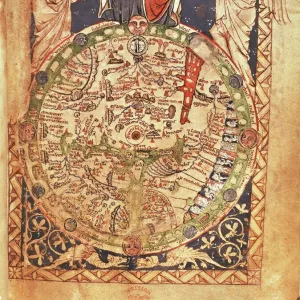
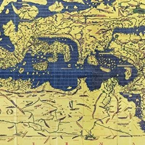
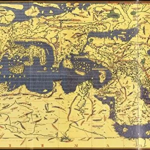
Jigsaw Puzzle : Copy made in Cairo in 1456 of the world map prepared by the Arab geographer Muhammad al-Idrisi


![]()
Jigsaw Puzzles from Universal Images Group (UIG)
Copy made in Cairo in 1456 of the world map prepared by the Arab geographer Muhammad al-Idrisi
Copy made in Cairo in 1456 of the world map prepared by the Arab geographer Muhammad al-Idrisi (1100-1165) for Roger II (1095-1154) King of Sicily from 1130. In this map, North is at the bottom
Universal Images Group (UIG) manages distribution for many leading specialist agencies worldwide
Media ID 9756859
© Universal History Archive/Universal Images Group
12th Arab Bottom Cairo Century Commerce Copy Geographer King Muhammad North Prepared Roger Sicily Trade Twelfth 1130 1456 Al Idrisi
Jigsaw Puzzle (520 Pieces)
Discover the rich history of cartography with our exquisite jigsaw puzzle from Media Storehouse, featuring a captivating reproduction of a world map created in Cairo in 1456. This intricately detailed puzzle showcases the work of the renowned Arab geographer Muhammad al-Idrisi, prepared for Roger II, King of Sicily. Delve into the fascinating world of medieval cartography as you piece together this beautiful puzzle, revealing the intricate depictions of continents, oceans, and exotic locales that reflect the knowledge of the time. A perfect addition to any home or office, this puzzle is not just a fun activity, but an educational journey back in time. Immerse yourself in history with the Media Storehouse jigsaw puzzle collection.
Made in the USA, 520-piece puzzles measure 16" x 20" (40.6 x 50.8 cm). Every puzzle is meticulously printed on glossy photo paper, which has a strong 1.33 mm thickness. Delivered in a black storage cardboard box, these puzzles are both stylish and practical. (Note: puzzles contain small parts and are not suitable for children under 3 years of age.)
Jigsaw Puzzles are an ideal gift for any occasion
Estimated Product Size is 40.5cm x 50.8cm (15.9" x 20")
These are individually made so all sizes are approximate
Artwork printed orientated as per the preview above, with landscape (horizontal) or portrait (vertical) orientation to match the source image.
EDITORS COMMENTS
This print showcases a remarkable piece of history - a copy made in Cairo in 1456 of the world map prepared by the esteemed Arab geographer Muhammad al-Idrisi for Roger II, the King of Sicily during the 12th century. In this intricate map, an intriguing twist awaits as North is depicted at the bottom rather than its conventional position at the top. The significance of this map lies not only in its stunning cartography but also in its representation of a pivotal era marked by exploration and trade. It serves as a testament to the flourishing commerce and cultural exchange that characterized this period between different regions across the globe. Muhammad al-Idrisi's meticulous craftsmanship and geographical knowledge are evident through his detailed depiction of various lands, seas, and continents. This masterpiece provides invaluable insights into how people perceived and understood our world centuries ago. As we delve into this image, we are transported back to Cairo in 1456 when skilled artisans worked diligently to reproduce al-Idrisi's original creation for future generations to admire. The delicate lines and vibrant colors bring life to each corner of this ancient map, inviting us on an imaginary journey through time. Let us marvel at this extraordinary artifact that bridges cultures, connects historical figures like Roger II with Muhammad al-Idrisi, and reminds us of humanity's ceaseless quest for knowledge about our planet.
MADE IN THE USA
Safe Shipping with 30 Day Money Back Guarantee
FREE PERSONALISATION*
We are proud to offer a range of customisation features including Personalised Captions, Color Filters and Picture Zoom Tools
SECURE PAYMENTS
We happily accept a wide range of payment options so you can pay for the things you need in the way that is most convenient for you
* Options may vary by product and licensing agreement. Zoomed Pictures can be adjusted in the Cart.