Jigsaw Puzzle > Universal Images Group (UIG) > History
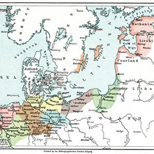
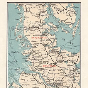
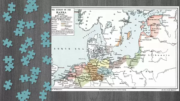
Jigsaw Puzzle : Map of the extent of the Hanseatic League in about 1400


![]()
Jigsaw Puzzles from Universal Images Group (UIG)
Map of the extent of the Hanseatic League in about 1400
Universal Images Group (UIG) manages distribution for many leading specialist agencies worldwide
Media ID 9763835
© Universal History Archive/Universal Images Group
1400 Baltic German Hanseatic League Merchants Trade Extent
Jigsaw Puzzle (1014 Pieces)
Discover the rich history of the Hanseatic League with our intricately designed jigsaw puzzle from Media Storehouse. This captivating puzzle features a detailed map of the Hanseatic League's extent in approximately 1400, as depicted in this authentic image from Universal Images Group. Assemble this puzzle to bring the economic and political power of this medieval trading alliance to life in your home. Engage in a stimulating and rewarding experience that not only challenges your problem-solving skills but also transports you to an era of maritime trade and diplomacy. Immerse yourself in history with Media Storehouse's Hanseatic League Jigsaw Puzzle.
Made in the USA, 1014-piece puzzles measure 20" x 30" (50.8 x 76.2 cm). Every puzzle is meticulously printed on glossy photo paper, which has a strong 1.33 mm thickness. Delivered in a black storage cardboard box, these puzzles are both stylish and practical. (Note: puzzles contain small parts and are not suitable for children under 3 years of age.)
Jigsaw Puzzles are an ideal gift for any occasion
Estimated Product Size is 76cm x 50.8cm (29.9" x 20")
These are individually made so all sizes are approximate
Artwork printed orientated as per the preview above, with landscape (horizontal) orientation to match the source image.
EDITORS COMMENTS
This print showcases a historical treasure, the "Map of the extent of the Hanseatic League in about 1400". The Hanseatic League, an influential alliance of German merchants during the late Middle Ages, left an indelible mark on European trade and history. This meticulously detailed map transports us back to a time when bustling ports dotted the Baltic Sea coastline. As we delve into this visual masterpiece, we witness how this league expanded its reach across vast territories. From Lübeck to Novgorod, from Bergen to Bruges, it vividly illustrates the extensive network that facilitated prosperous trade routes. Each city is marked with precision and adorned with symbols representing their unique contributions to commerce. The significance of this map lies not only in its cartographic excellence but also in what it represents: unity amidst diversity. It symbolizes how diverse communities came together under one banner for mutual economic benefit and protection. The Hanseatic League fostered cultural exchange while safeguarding merchant interests through diplomatic negotiations and shared regulations. Through this image, we are transported back in time to witness a pivotal moment in European history—a testament to human ingenuity and cooperation. It serves as a reminder that even centuries ago, international trade played a crucial role in shaping societies and fostering connections between distant lands. Thanks to Universal Images Group (UIG), we can now appreciate this remarkable piece of history preserved within this stunning print – an invitation for exploration into the rich tapestry of medieval Europe's commercial past.
MADE IN THE USA
Safe Shipping with 30 Day Money Back Guarantee
FREE PERSONALISATION*
We are proud to offer a range of customisation features including Personalised Captions, Color Filters and Picture Zoom Tools
SECURE PAYMENTS
We happily accept a wide range of payment options so you can pay for the things you need in the way that is most convenient for you
* Options may vary by product and licensing agreement. Zoomed Pictures can be adjusted in the Cart.