Home > South America > Bolivia > Maps
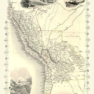
1864, Mitchell Map of Brazil, Bolivia and Chili, topography, cartography, geography

![]()
Wall Art and Photo Gifts from Liszt Collection
1864, Mitchell Map of Brazil, Bolivia and Chili, topography, cartography, geography
1864, Mitchell Map of Brazil, Bolivia and Chili
Liszt Collection of nineteenth-century engravings and images to browse and enjoy
Media ID 14006041
© Artokoloro Quint Lox Limited
1864 Antique Map Atlas Chart Geographic Latitude Longitude Mappa Mundi Old Antique Plan Old Antique View Old Map Ols Antique Map Rare Old Maps Topo
FEATURES IN THESE COLLECTIONS
> Maps and Charts
> Early Maps
> Maps and Charts
> World
> South America
> Bolivia
> Maps
> South America
> Brazil
> Maps
EDITORS COMMENTS
This print showcases the remarkable 1864 Mitchell Map of Brazil, Bolivia, and Chili. A true masterpiece of topography, cartography, and geography, this vintage map takes us back in time to explore the intricate details of these South American countries. The artist's skillful illustration brings to life the diverse landscapes and geographic features that define this region. With its carefully plotted grid lines of latitude and longitude, this ancient map served as a valuable tool for navigation during a time when technology was limited. Its geometric precision and meticulous attention to detail make it an invaluable historical artifact. The aged paper adds a touch of nostalgia to this decorative piece while reminding us of the rich history embedded within its fibers. This rare old map invites us on a journey through time, offering glimpses into past discoveries and explorations that have shaped our understanding of the world. As we gaze upon this fascinating mappa mundi, we are transported to an era where exploration was both challenging and awe-inspiring. It serves as a reminder of how far we have come in our quest for geographical knowledge while honoring those who paved the way before us. Whether displayed in a study or adorning the walls of an art collector's gallery, this antique map is sure to captivate all who lay eyes upon it with its timeless beauty and historical significance.
MADE IN THE USA
Safe Shipping with 30 Day Money Back Guarantee
FREE PERSONALISATION*
We are proud to offer a range of customisation features including Personalised Captions, Color Filters and Picture Zoom Tools
SECURE PAYMENTS
We happily accept a wide range of payment options so you can pay for the things you need in the way that is most convenient for you
* Options may vary by product and licensing agreement. Zoomed Pictures can be adjusted in the Cart.