Home > Europe > United Kingdom > Scotland > Stirlingshire > Stirling
Birmingham B16 9 Map

![]()
Wall Art and Photo Gifts from Map Marketing
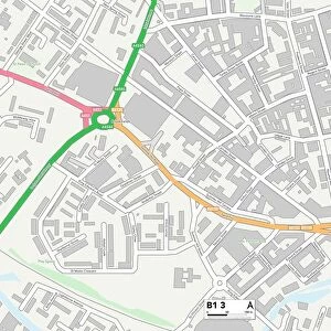
Birmingham B16 9 Map
Postcode Sector Map of Birmingham B16 9
Media ID 19965309
Anchor Close Ascot Close Birmingham Carlyle Road Christchurch Close Clarendon Road Daisy Road Eldon Road Harold Road Holly Road Leslie Road Lyttelton Road Manor Road Melville Road Montague Road Moorland Road Mostyn Road Parker Street Percival Road Reservoir Road Sefton Road Shire Close St Augustines Road Stanmore Road Station Avenue Stirling Road Vernon Road Waterworks Road Wyndham Road York Road Hagley Road
FEATURES IN THESE COLLECTIONS
> Europe
> United Kingdom
> Scotland
> Stirlingshire
> Stirling
> Map Marketing
> Postcode Sector Maps
> B - Birmingham
> Maps and Charts
> Related Images
MADE IN THE USA
Safe Shipping with 30 Day Money Back Guarantee
FREE PERSONALISATION*
We are proud to offer a range of customisation features including Personalised Captions, Color Filters and Picture Zoom Tools
SECURE PAYMENTS
We happily accept a wide range of payment options so you can pay for the things you need in the way that is most convenient for you
* Options may vary by product and licensing agreement. Zoomed Pictures can be adjusted in the Cart.