Home > Animals > Birds > Passerines > Crows And Jays > Little Raven
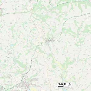
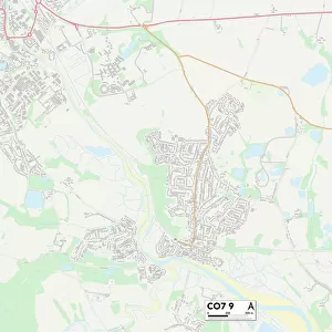
Tendring CO16 9 Map

![]()
Wall Art and Photo Gifts from Map Marketing
Tendring CO16 9 Map
Postcode Sector Map of Tendring CO16 9
Media ID 19968720
Alexandra Road Barrack Lane Barrington Close Bentley Road Brookfield Road Centenary Way Chantry Close Church Lane Clacton Road Clay Lane Colchester Road Connaught Road Crow Lane Dead Lane Edward Close Edward Road Elm Road Festival Close First Avenue Galloway Drive Green Lane Grove Road Harwich Road Heath Road Hilltop Crescent Holland Road Honeypot Lane Jubilee Avenue Lambourne Close Lodge Road London Road Mill Lane Millers Green Oakleigh Close Progress Way Rectory Road Second Avenue St Andrews Close St Andrews Road Talbot Road Tendring The Street The Willows Thorpe Road Victoria Road Wenlock Road Wick Lane Woodlands Rise
FEATURES IN THESE COLLECTIONS
> Animals
> Birds
> Passerines
> Crows And Jays
> Little Raven
> Animals
> Birds
> Passerines
> Crows And Jays
> Related Images
> Animals
> Mammals
> Muridae
> Heath Mouse
> Arts
> Artists
> C
> Edward Clay
> Europe
> United Kingdom
> England
> London
> Events
> Related Images
> Europe
> United Kingdom
> England
> London
> Politics
> Edward Heath
> Europe
> United Kingdom
> England
> London
> Sights
> Green Park
> Europe
> United Kingdom
> England
> London
> Sights
> Holland Park
> Europe
> United Kingdom
> England
> London
> Sights
> Victoria Park
> Europe
> United Kingdom
> England
> London
> Towns
> Elm Park
> Map Marketing
> Postcode Sector Maps
> CO - Colchester
MADE IN THE USA
Safe Shipping with 30 Day Money Back Guarantee
FREE PERSONALISATION*
We are proud to offer a range of customisation features including Personalised Captions, Color Filters and Picture Zoom Tools
SECURE PAYMENTS
We happily accept a wide range of payment options so you can pay for the things you need in the way that is most convenient for you
* Options may vary by product and licensing agreement. Zoomed Pictures can be adjusted in the Cart.