Home > Arts > Artists > C > Frederick Church
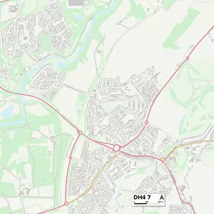
Sunderland DH4 7 Map

![]()
Wall Art and Photo Gifts from Map Marketing
Sunderland DH4 7 Map
Postcode Sector Map of Sunderland DH4 7
Media ID 19968785
Alpine Close Ashdale Aspen Close Avondale Avenue Back Lane Bell Street Brentwood Road Burnham Close Catherine Road Chester Road Chislehurst Road Church Street Claremont Drive Collingwood Drive Derwent Street Devon Street Douglas Terrace Elliot Close Elm Grove Eskdale Fenwick Close Fenwick Street Ferndale Road Gainsborough Crescent Garden Place Helmsley Close Highfield Road Hill Lane Kingswood Langdale Road Medlar Close Monument View Mount Pleasant Oakmere Close Ribblesdale St Pauls Drive Station Road Sunderland Surrey Street Sutton Close Teesdale Avenue The Haven The Poplars Thornton Close Wallis Street Wensleydale Avenue Westerdale Wharfedale Windermere Crescent Bonaventure Cottonwood Dentdale Foxglove Highclere Hornbeam Maidenhair The Cove
FEATURES IN THESE COLLECTIONS
> Arts
> Artists
> C
> Frederick Church
> Europe
> France
> Canton
> Marne
> Europe
> United Kingdom
> England
> Devon
> Church Green
> Europe
> United Kingdom
> England
> Devon
> Cove
> Europe
> United Kingdom
> England
> Devon
> Cross Green
> Europe
> United Kingdom
> England
> Devon
> Ford
> Europe
> United Kingdom
> England
> Devon
> Related Images
> Europe
> United Kingdom
> England
> Devon
> West Hill
> Europe
> United Kingdom
> England
> Surrey
> Kingswood
> Europe
> United Kingdom
> England
> Surrey
> Related Images
> Map Marketing
> Postcode Sector Maps
> DH - Durham
MADE IN THE USA
Safe Shipping with 30 Day Money Back Guarantee
FREE PERSONALISATION*
We are proud to offer a range of customisation features including Personalised Captions, Color Filters and Picture Zoom Tools
SECURE PAYMENTS
We happily accept a wide range of payment options so you can pay for the things you need in the way that is most convenient for you
* Options may vary by product and licensing agreement. Zoomed Pictures can be adjusted in the Cart.