Home > Europe > United Kingdom > England > London > Towns > Elmstead
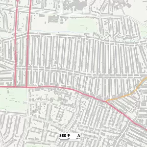
Thurrock SS17 9 Map

![]()
Wall Art and Photo Gifts from Map Marketing
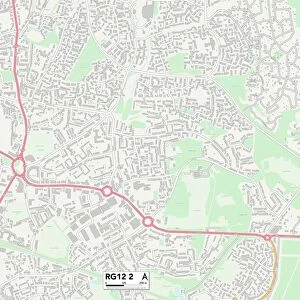
Thurrock SS17 9 Map
Postcode Sector Map of Thurrock SS17 9
Media ID 19978768
Birchwood Road Brook Drive Church Road Clarence Road Digby Road Glenfield Road High Road Hill Terrace Kenwood Road Larkfield Manor Way Marie Close Marsh Lane Mill Lane Oakwood Road Parkway Recreation Avenue Sheldon Close South Road The Avenue The Hawthorns Thurrock Waterworks Lane Wharf Road Wheatley Road Whitehall Lane Woodlands Drive Atlantic Avenue Lion Hill Ocean Boulevard
FEATURES IN THESE COLLECTIONS
> Abstract Art
> Rainbows
> Animals
> Birds
> Passerines
> Finches
> Related Images
> Europe
> United Kingdom
> England
> London
> Sights
> Whitehall
> Europe
> United Kingdom
> England
> London
> Towns
> Elmstead
> Europe
> United Kingdom
> England
> London
> Towns
> Mill Hill
> Europe
> United Kingdom
> England
> London
> Towns
> Oakwood
> Map Marketing
> Postcode Sector Maps
> SS - Southend-on-Sea
MADE IN THE USA
Safe Shipping with 30 Day Money Back Guarantee
FREE PERSONALISATION*
We are proud to offer a range of customisation features including Personalised Captions, Color Filters and Picture Zoom Tools
SECURE PAYMENTS
We happily accept a wide range of payment options so you can pay for the things you need in the way that is most convenient for you
* Options may vary by product and licensing agreement. Zoomed Pictures can be adjusted in the Cart.