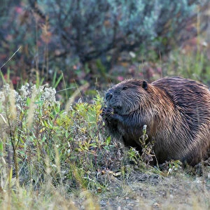
Home > Animals > Mammals > Aplodontiidae > Mountain Beaver
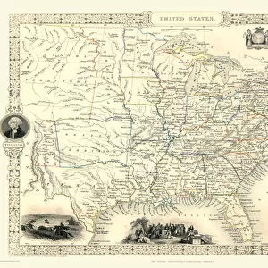
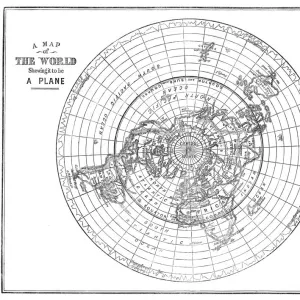
Old Map of North America 1851 by John Tallis

![]()
Wall Art and Photo Gifts from MapSeeker
Old Map of North America 1851 by John Tallis
A fine reproduction artworked from an antique original map of North America, issued as part of the 1851 edition of John Tallis and Companys " The Illustrated Atlas and Modern History of the World". Made shortly following the entry of Texas into the Union, this map depicts an important point in American history. Herein Texas is shown at near its fullest extent including Santa Fe and but excluding the Green Mountain extension in the Northwest. Upper California has yet to become a part of the United States and while Oregon is included, Washington remains a part of British America. The mythical Buenaventure River appears in northern California. The map displays several beautiful vignettes depicting oNorth American Indianso, a oWhite Dearo, Beavers, the oFalls of Niagarao, a oConvoy of Diamondso, an oAncient Monument, Mexicoo, oCossackso, and the Esquimaux Dog-Sledge. The map is surrounded by a highly decorative border
Welcome to the Mapseeker Image library and enter an historic gateway to one of the largest on-line collections of Historic Maps, Nostalgic Views, Vista's and Panorama's from a World gone by.
Media ID 20347406
© Mapseeker Publishing Ltd
John Tallis John Tallis Map Tallis Tallis Map Northern America
FEATURES IN THESE COLLECTIONS
> Animals
> Mammals
> Aplodontiidae
> Mountain Beaver
> Animals
> Mammals
> Castoridae
> American Beaver
> Animals
> Mammals
> Cricetidae
> California Mouse
> Arts
> Artists
> T
> John Tallis
> Historic
> Monuments and landmarks
> Monuments and memorials
> Maps and Charts
> Related Images
> Maps and Charts
> World
EDITORS COMMENTS
This stunning print showcases the "Old Map of North America 1851" by John Tallis, a renowned cartographer. Reproduced from an antique original map, this artwork is a testament to the rich history and intricate craftsmanship of cartography in the mid-19th century. The map itself captures a pivotal moment in American history, as it was created shortly after Texas joined the Union. It vividly portrays Texas at near its fullest extent, including Santa Fe but excluding the Green Mountain extension in the Northwest. Upper California has yet to become part of the United States, while Washington remains under British control. Interestingly, a mythical river called Buenaventure can be found in northern California. Surrounding this meticulously detailed map is an exquisitely ornate border that adds to its visual appeal. The border frames several beautiful vignettes depicting various aspects of North American life and culture: Native Americans, a majestic white deer, beavers, Niagara Falls, diamond convoys, an ancient monument in Mexico City, Cossacks on horseback, and an Esquimaux dog-sledge. This reproduction allows us to appreciate both the historical significance and artistic beauty of Tallis' work. Whether you are fascinated by old maps or intrigued by American history during this era of expansion and exploration, this print will transport you back in time to experience North America as it once was – full of uncharted territories and cultural diversity.
MADE IN THE USA
Safe Shipping with 30 Day Money Back Guarantee
FREE PERSONALISATION*
We are proud to offer a range of customisation features including Personalised Captions, Color Filters and Picture Zoom Tools
SECURE PAYMENTS
We happily accept a wide range of payment options so you can pay for the things you need in the way that is most convenient for you
* Options may vary by product and licensing agreement. Zoomed Pictures can be adjusted in the Cart.