Home > Europe > United Kingdom > England > London > Sights > Tower of London
Early Coastal Survey Map of the Isle of Portsea and Portsmouth Harbour 1716

![]()
Wall Art and Photo Gifts from MapSeeker
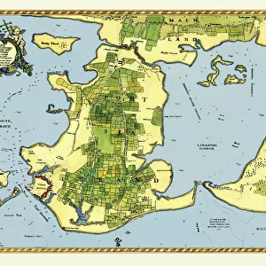
Early Coastal Survey Map of the Isle of Portsea and Portsmouth Harbour 1716
This is a reproduction in colour of the early chart of the Island of Portsea and Portsmouth Harbour. In January 1715/6, in the last stages of the Jacobite emergency, Talbot Edwards, Second Engineer of England and Wales, was appointed to carry out a complete survey and report of the fortifications, barracks and storehouses in the Portsmouth divi-sion and during the year he produced maps of the old town, the Dockyard and the harbour as well as the present map of Portsea Island as a whole. Although unsigned the map was probably surveyed under the personal direction of Edwards and was drawn by Clement Lempriere. Lemprieres foreOEname was not known for certain when Maps of PortsOEmouth went to press, but it has now been conclusively established from an advertisement for a map of Jersey in The Public Advertiser, 5 May 1755. This map may be regarded on the whole as a very accurate delineation of the Island in 1716, although it is necessary to be a little cautious about the reliaOEbility of the field pattern which seems rather too regular, suggesting that a conventionalised element has been introduced. Certainly the map was regarded as accurate by the Drawing Room of the Board of Ordnance at the Tower of London, who used it as the base-map of the Island for about 50 years; even when widespread new surveys were carOEried out from 1743 these were merely incorporated into Edwardss old design
Welcome to the Mapseeker Image library and enter an historic gateway to one of the largest on-line collections of Historic Maps, Nostalgic Views, Vista's and Panorama's from a World gone by.
Media ID 20347489
FEATURES IN THESE COLLECTIONS
> Architecture
> Towers
> Tower of London
> Europe
> United Kingdom
> England
> London
> Sights
> Tower of London
> Europe
> United Kingdom
> England
> London
> Towns
> Welling
> Europe
> United Kingdom
> England
> Maps
> Europe
> United Kingdom
> England
> Portsmouth
> Europe
> United Kingdom
> England
> Wells
> Europe
> United Kingdom
> Wales
> Maps
> Europe
> United Kingdom
> Wales
> Posters
> Maps and Charts
> Early Maps
> Maps and Charts
> Related Images
> MapSeeker
> Maps from the British Isles
> British Coastal Surveys PORTFOLIO
EDITORS COMMENTS
This vibrant reproduction of the early coastal survey map of the Isle of Portsea and Portsmouth Harbour in 1716 takes us back to a crucial moment in history. During the Jacobite emergency, Talbot Edwards, Second Engineer of England and Wales, was entrusted with the task of thoroughly surveying and reporting on the fortifications, barracks, and storehouses in the Portsmouth division. This particular map is believed to have been surveyed under Edwards' personal direction and expertly drawn by Clement Lempriere. While unsigned, this map has proven to be remarkably accurate over time. The Drawing Room of the Board of Ordnance at the Tower of London even used it as their base-map for approximately half a century. Despite subsequent surveys conducted from 1743 onwards, Edward's original design remained highly regarded. Examining this print closely reveals intricate details that showcase not only geographical features but also field patterns. However, one must exercise caution when interpreting these patterns as they may have been slightly conventionalized or stylized for visual appeal. As we gaze upon this piece, we are transported back to an era where meticulous cartography played a vital role in military strategy and defense planning. It serves as a testament to both Talbot Edwards' expertise as an engineer and Clement Lempriere's skillful artistry in bringing this historical landscape to life through cartographic representation.
MADE IN THE USA
Safe Shipping with 30 Day Money Back Guarantee
FREE PERSONALISATION*
We are proud to offer a range of customisation features including Personalised Captions, Color Filters and Picture Zoom Tools
SECURE PAYMENTS
We happily accept a wide range of payment options so you can pay for the things you need in the way that is most convenient for you
* Options may vary by product and licensing agreement. Zoomed Pictures can be adjusted in the Cart.