Home > Arts > Photorealistic artworks > Detailed art pieces > Masterful detailing in art
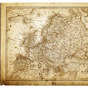
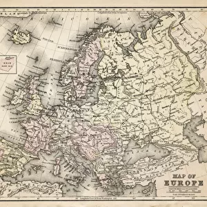
Old Map of Europe 1852 by Henry George Collins

![]()
Wall Art and Photo Gifts from MapSeeker
Old Map of Europe 1852 by Henry George Collins
This is a finely detailed map of Europe remastered from a rare Atlas of the World published in 1852 by Henry George Collins. Although these Henry Collins produced maps of the highest quality in his time unfortunately not the same could be said in terms of his business success. His maps were later obtained by the famous Stanford Map Company and used in their publications
Welcome to the Mapseeker Image library and enter an historic gateway to one of the largest on-line collections of Historic Maps, Nostalgic Views, Vista's and Panorama's from a World gone by.
Media ID 20347285
© Mapseeker Publishing Ltd
Collins Collins Atlas Collins Atlas Map Collins Map Continental Map Europe Europe Map Map Of Europe Old Continental Map
FEATURES IN THESE COLLECTIONS
> Arts
> Photorealistic artworks
> Detailed art pieces
> Masterful detailing in art
> Maps and Charts
> Related Images
> Maps and Charts
> World
> MapSeeker
> Maps of Europe
> Old Maps of Europe and Small Islands of
EDITORS COMMENTS
This beautifully preserved print showcases the "Old Map of Europe 1852" by Henry George Collins, a renowned cartographer of his time. Remastered from a rare Atlas of the World published in 1852, this map offers an intricate and detailed depiction of Europe during that era. Henry Collins was widely recognized for producing maps of exceptional quality, as evidenced by this remarkable piece. However, despite his talent and dedication to his craft, he faced challenges when it came to achieving business success. Fortunately, his invaluable maps found their way into the hands of the esteemed Stanford Map Company, who incorporated them into their own publications. As we explore this historic map, we are transported back in time to witness Europe's geographical landscape as it stood over a century ago. The contours and boundaries meticulously outlined on this old European map provide us with insights into how nations were shaped and territories defined during that period. The Collins Atlas holds great significance among collectors and enthusiasts alike due to its accuracy and attention to detail. This particular print serves as a testament not only to Henry George Collins' expertise but also to the enduring legacy of these timeless cartographic works. Whether you are an avid historian or simply captivated by the beauty of antique maps, this Old Map of Europe 1852 is sure to be cherished for generations to come.
MADE IN THE USA
Safe Shipping with 30 Day Money Back Guarantee
FREE PERSONALISATION*
We are proud to offer a range of customisation features including Personalised Captions, Color Filters and Picture Zoom Tools
SECURE PAYMENTS
We happily accept a wide range of payment options so you can pay for the things you need in the way that is most convenient for you
* Options may vary by product and licensing agreement. Zoomed Pictures can be adjusted in the Cart.