Home > Europe > United Kingdom > England > London > Museums > National Army Museum
The Invasions of England and Ireland With al [sic] their Civ
![The Invasions of England and Ireland With al [sic] their Civ](/p/164/invasions-england-ireland-al-sic-civ-14389835.jpg.webp "The Invasions of England and Ireland With al [sic] their Civ")
![]()
Wall Art and Photo Gifts from Mary Evans Picture Library
The Invasions of England and Ireland With al [sic] their Civ
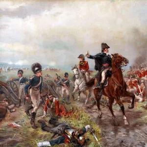
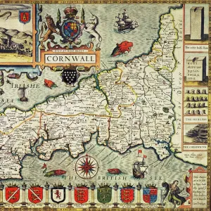
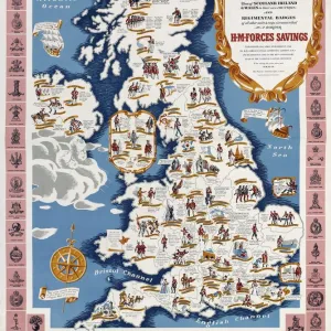
Map: The Invasions of England and Ireland With al [sic] their Civill [sic] Wars since the Conquest Corn Danckertsz sculpsit [London] George Humble, 1627 (c). Framed hand-coloured and engraved map by John Speed. Depicts the locations of various battles, invasions and naval engagements in the British Isles since 1066, including the Wars of the Roses (1455-1485) and the Spanish Armada (1586-1588). Date: 1066
Mary Evans Picture Library makes available wonderful images created for people to enjoy over the centuries
Media ID 14389835
© The National Army Museum / Mary Evans Picture Library
1066 1627 Conquest Corn Engraved Humble Invasions Norman Speed Wars Sculpsit
FEATURES IN THESE COLLECTIONS
> Arts
> Artists
> S
> John Speed
> Europe
> Republic of Ireland
> Maps
> Europe
> United Kingdom
> England
> London
> Museums
> British Museum
> Europe
> United Kingdom
> England
> London
> Museums
> National Army Museum
> Europe
> United Kingdom
> England
> Maps
> Historic
> Battles
> Related Images
EDITORS COMMENTS
This intricately detailed and beautifully hand-colored map, titled "The Invasions of England and Ireland With al [sic] their Civill [sic] Wars since the Conquest," is a fascinating glimpse into the rich and complex history of the British Isles. Created by the renowned cartographer John Speed in 1627, this map was sculpted by Cornelis Danckerts and published by George Humble. The map meticulously depicts the locations of various battles, invasions, and naval engagements that have shaped the history of England and Ireland since the Norman Conquest of 1066. The invasions and wars represented on this map include the Anarchy, or the Wars of the Roses (1455-1485), which saw the House of Lancaster and the House of York vying for the English throne, and the Spanish Armada (1586-1588), a failed invasion of England by the Spanish fleet. The map also highlights significant battles such as the Battle of Hastings (1066), where William the Conqueror defeated Harold Godwinson to claim the English throne, and the Battle of Bosworth Field (1485), where Henry Tudor defeated Richard III to become Henry VII and establish the Tudor dynasty. This map is a testament to the rich and complex history of the British Isles, providing a visual representation of the various conflicts and invasions that have shaped the region's political and cultural landscape. The intricate detail and beautiful hand-coloring make this a stunning addition to any historical collection.
MADE IN THE USA
Safe Shipping with 30 Day Money Back Guarantee
FREE PERSONALISATION*
We are proud to offer a range of customisation features including Personalised Captions, Color Filters and Picture Zoom Tools
SECURE PAYMENTS
We happily accept a wide range of payment options so you can pay for the things you need in the way that is most convenient for you
* Options may vary by product and licensing agreement. Zoomed Pictures can be adjusted in the Cart.