Home > Maps and Charts > Africa
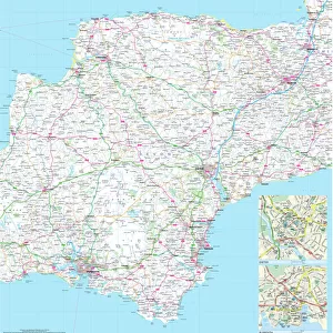
Map Showing Routes of the Union Castle Line to Africa

![]()
Wall Art and Photo Gifts from Mary Evans Picture Library
Map Showing Routes of the Union Castle Line to Africa
Map Showing Routes of the Union Castle Line to Africa, . Date: 1927
Mary Evans Picture Library makes available wonderful images created for people to enjoy over the centuries
Media ID 14204000
© The Wentworth Collection / Mary Evans Picture Library
FEATURES IN THESE COLLECTIONS
> Africa
> Related Images
> Maps and Charts
> Early Maps
> Maps and Charts
> Related Images
EDITORS COMMENTS
1. Title: Voyages of Discovery and Connection: The Union Castle Line's Maritime Routes to Africa (1927) This map, dated 1927, depicts the intricate and extensive maritime routes of the Union Castle Line to Africa. The Union Castle Line was a renowned British shipping company that operated regular passenger and cargo services between the United Kingdom and various African countries, including South Africa, Nigeria, and Ghana, among others. The map showcases the rich history of maritime travel and the connections between Africa and Europe during the early 20th century. The intricate network of lines on the map illustrates the company's extensive reach, with routes stretching from the shores of England to the western and eastern coasts of Africa. The Union Castle Line played a significant role in the historical narrative of transatlantic travel, as it facilitated the movement of people, goods, and ideas between the two continents. The company's ships carried not only passengers seeking new opportunities and adventures but also essential commodities, such as coal, machinery, and manufactured goods, which fueled the economic growth of African colonies. Moreover, the map serves as a visual reminder of the profound impact of European colonialism on Africa, as the lines connecting the continents represent not only commercial and economic ties but also the political and cultural influences that shaped the African continent during this period. In summary, this 1927 map of the Union Castle Line's routes to Africa offers a fascinating glimpse into the history of maritime travel and the complex web of connections between Africa and Europe during the early 20th century. It is a testament to the enduring legacy of the Union Castle Line and the role it played in shaping the global narrative of exploration, commerce, and cultural exchange.
MADE IN THE USA
Safe Shipping with 30 Day Money Back Guarantee
FREE PERSONALISATION*
We are proud to offer a range of customisation features including Personalised Captions, Color Filters and Picture Zoom Tools
SECURE PAYMENTS
We happily accept a wide range of payment options so you can pay for the things you need in the way that is most convenient for you
* Options may vary by product and licensing agreement. Zoomed Pictures can be adjusted in the Cart.