Home > Animals > Extinct > Dinosaurs
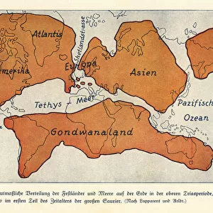
Map of the continents and seas in the Upper Carboniferous

![]()
Wall Art and Photo Gifts from Mary Evans Picture Library
Map of the continents and seas in the Upper Carboniferous
Map of the continents and seas in the Upper Carboniferous era. Atlantis, North America, Asia, European Peninsula, Gondwanaland. Colour print after an illustration from Wilhelm Bolsches Das Leben der Urwelt, Prehistoric Life, Georg Dollheimer, Leipzig, 1932
Mary Evans Picture Library makes available wonderful images created for people to enjoy over the centuries
Media ID 23381454
© Florilegius
Bolsche Carboniferous Continents Creature Dinosaurs Extinct Herbivorous Hugo Leben Maage Megalosaurus Paleontology Predatory Prehistoric Prehistory Seas Urwelt Wilhelm Wolff Upper
FEATURES IN THESE COLLECTIONS
> Animals
> Extinct
> Dinosaurs
> Asia
> Related Images
> Maps and Charts
> Related Images
> Mary Evans Prints Online
> New Images August 2021
> North America
> Related Images
EDITORS COMMENTS
Step back in time with this color print of the continents and seas during the Upper Carboniferous era, around 318 to 299 million years ago. This intricately detailed map, based on an illustration from Wilhelm Bolsche's "Prehistoric Life" published in 1932, invites us to explore a world long gone. During the Upper Carboniferous, the supercontinent Pangaea began to take shape as the continents began to converge. The map shows the early configurations of continents such as North America, Europe, and Asia, as well as the vast southern landmass known as Gondwanaland. The continents were connected by land bridges, allowing for the exchange of flora and fauna between these landmasses. The seas teemed with life, including a variety of marine creatures, some of which are now extinct. The map also highlights the distribution of various plant life, including the first forests, which dominated the landscape during this period. The Upper Carboniferous was also a time of evolutionary innovation. Herbivorous dinosaurs, such as the iguanodons, began to emerge, as did their predatory counterparts like the megalosaurus. This era marked the beginning of the age of reptiles and the end of the Paleozoic era. This map is a testament to the rich history of our planet and the wonders of prehistory. It invites us to explore the natural world and the incredible creatures that once roamed and swam the Earth. Whether you're a student of zoology, paleontology, or just someone with a curiosity for the natural world, this map is a must-see.
MADE IN THE USA
Safe Shipping with 30 Day Money Back Guarantee
FREE PERSONALISATION*
We are proud to offer a range of customisation features including Personalised Captions, Color Filters and Picture Zoom Tools
SECURE PAYMENTS
We happily accept a wide range of payment options so you can pay for the things you need in the way that is most convenient for you
* Options may vary by product and licensing agreement. Zoomed Pictures can be adjusted in the Cart.