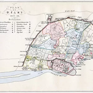
Metal Print > North America > Nicaragua > Lakes > Lake Nicaragua
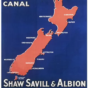
Metal Print : Map showing the Nicaraguan Canal, a proposed shipping route through Nicaragua via Lake Nicaragua in the first decade of the 20th century, which would have connected the Atlantic and the Pacific Oceans. The plan never went ahead after the building of the Panama canal. From The Business Encyclopaedia and Legal Adviser, published 1907


![]()
Metal Prints from Design Pics
Map showing the Nicaraguan Canal, a proposed shipping route through Nicaragua via Lake Nicaragua in the first decade of the 20th century, which would have connected the Atlantic and the Pacific Oceans. The plan never went ahead after the building of the Panama canal. From The Business Encyclopaedia and Legal Adviser, published 1907
Design Pics offers Distinctively Different Imagery representing over 1,500 contributors
Media ID 24905680
© Ken Welsh
20th Century Atlantic Ocean Canals Central America Central American Connected Connection Man Made Pacific Ocean Plan Waterway Waterways Lake Nicaragua Nicaragua Proposed Shipping Route
16"x20" (51x41cm) Metal Print
Step back in time with our vintage Map Print featuring the proposed Nicaraguan Canal from the early 20th century. This intriguing piece of history illustrates an alternate shipping route between the Atlantic and Pacific Oceans, as planned via Lake Nicaragua. Though the project never came to fruition after the completion of the Panama Canal, this captivating map offers a glimpse into the engineering ambitions of the past. Add a touch of historical charm to your space with our high-quality Metal Print from Media Storehouse's extensive collection.
Made with durable metal and luxurious printing techniques, our metal photo prints go beyond traditional canvases, adding a cool, modern touch to your space. Wall mount on back. Eco-friendly 100% post-consumer recycled ChromaLuxe aluminum surface. The thickness of the print is 0.045". Featuring a Scratch-resistant surface and Rounded corners. Backing hangers are attached to the back of the print and float the print 1/2-inch off the wall when hung, the choice of hanger may vary depending on size and International orders will come with Float Mount hangers only. Finished with a brilliant white high gloss surface for unsurpassed detail and vibrance. Printed using Dye-Sublimation and for best care we recommend a non-ammonia glass cleaner, water, or isopropyl (rubbing) alcohol to prevent harming the print surface. We recommend using a clean, lint-free cloth to wipe off the print. The ultra-hard surface is scratch-resistant, waterproof and weatherproof. Avoid direct sunlight exposure.
Made with durable metal and luxurious printing techniques, metal prints bring images to life and add a modern touch to any space
Estimated Image Size (if not cropped) is 50.8cm x 40.6cm (20" x 16")
Estimated Product Size is 51.4cm x 41.2cm (20.2" x 16.2")
These are individually made so all sizes are approximate
Artwork printed orientated as per the preview above, with landscape (horizontal) orientation to match the source image.
FEATURES IN THESE COLLECTIONS
> Maps and Charts
> Early Maps
> North America
> Nicaragua
> Lakes
> Lake Nicaragua
> North America
> Nicaragua
> Lakes
> Related Images
> North America
> Nicaragua
> Maps
> North America
> Nicaragua
> Related Images
> North America
> Panama
> Lakes
> Related Images
> North America
> Panama
> Maps
> North America
> Panama
> Related Images
EDITORS COMMENTS
This print showcases a historical map that unveils the ambitious proposal of the Nicaraguan Canal, an interoceanic shipping route through Nicaragua via Lake Nicaragua. Dating back to the early 1900s, this plan aimed to connect the Atlantic and Pacific Oceans, revolutionizing global trade and transportation. However, despite its promising potential, this grand vision never came to fruition due to the construction of the Panama Canal. The intricately detailed map highlights Central America's strategic location as a gateway between two vast bodies of water. It symbolizes human ingenuity and determination in conquering geographical barriers for economic progress. The archival image serves as a testament to our ancestors' aspirations for connectivity and exploration. As we gaze upon this piece from "The Business Encyclopaedia and Legal Adviser" published in 1907 by Ken Welsh, we are transported back in time to an era when man-made canals were considered engineering marvels. This illustration is not only visually striking but also holds immense historical significance. While it may be easy to dismiss this proposed canal as merely an unrealized dream, it remains an important part of our collective history—a reminder of how ideas shape our world even if they do not come into existence.
MADE IN THE USA
Safe Shipping with 30 Day Money Back Guarantee
FREE PERSONALISATION*
We are proud to offer a range of customisation features including Personalised Captions, Color Filters and Picture Zoom Tools
SECURE PAYMENTS
We happily accept a wide range of payment options so you can pay for the things you need in the way that is most convenient for you
* Options may vary by product and licensing agreement. Zoomed Pictures can be adjusted in the Cart.